
- You are here:
-
Home

- Recent Articles
Categories
Articles


October 6, 2017
These are talking points that can be used when addressing concerns to elected officials.
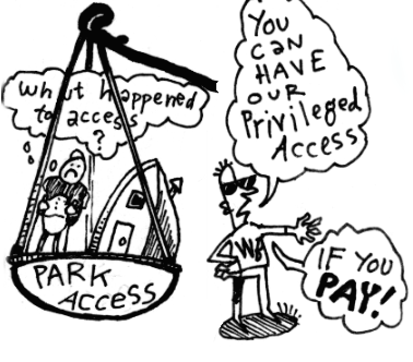
Parking and access to recreation opportunities is a huge issue in the Sea to Sky corridor.
The road slump on the Whistler side along the park access right-of-way is in a geologically unstable area. The right-of-way was "repaired" at a cost of $50,000 in the summer of 2016. The repaired area washed out a month later in October rains. Land surveys show the slump continues to move downhill...
Early 1900s, Singing Pass at the head of Fitzsimmons Creek had a history of mining and hunting prior to establishment of Garibaldi Provincial Park.
October, 1915 the British Columbia Mountaineering Club petitions the Minister of Lands to create a "park reserve in the Mount Garibaldi District...that its remarkable assemblage of glacial, volcanic and other natural features may be preserved unimpaired for the instruction and recreation of the people of Western Canada."
April 1917, the...

{loadmodule mod_edocman_documents,Recent Documents}
Click here for larger image: EPP37691.jpg
Click here for larger image: EPP37692.jpg
Click here for larger image: EPP37693.jpg
EPP3769 detail #1
Right-of-way plan EPP3768
Right-of-way plan EPP256
Click for a larger version: FitzsimmonsROW-Overview.jpg
Click for a larger version: FitzsimmonsROW1.jpg
Click for a larger version: FitzsimmonsROW2.jpg
Whistler-Blackcomb Park Deletions in context:
{GPSCONTENT ["id": 14, "elevation": 1, "speed": 1, "hr": 1]}
The map outline shows the 2016 Garibaldi Provincial Park boundary, Blackcomb Glacier Provicial Park boundary and the 1966 Garibaldi Provincial Park boundary.
Alternative Map/Presentation:
Trail and Backcountry User Information
https://bivouac.com North American Mountain Encyclopedia
https://www.vancouvertrails.com - Sponsor and Partner Trail Website of BackcountryBC
https://www.outdoorvancouver.ca
http://www.trailpeak.com
https://www.livetrails.com
http://www.doglotion.com/huts/ - Backcountry Hut Map for BC
Online Backcountry Recreation Communities
http://www.clubtread.com (Hiking Forum)
Facebook...
Issue Lead Advocate - Paul Kubik
The problem in a nutshell. Government tinkering has granted Whistler Blackcomb 33 km2 of Garibaldi Park. Mountain Resorts Branch is the provincial agency that oversees resort development and approvals for the province. In 2017, the provincial agency approved further expansion of Whistler Blackcomb resort while ignoring provisions of the resort's master development agreement that would have maintained and restored the Singing Pass parking lot up...
These are the issues for which we have an active campaign that members of Backcountry BC consider of escpecially high priority and have invested a great deal of time and reasources in trying to resolve.
To learn more about each issue, click on the links belowSave the Smoke Bluffs (Resolved)
Blackcomb Access Corridor
Singing Pass Issue Summary and Parking Proposal
Non motorized zones
Pinecone Burke Provincial Park Masterplan 2020
Commercial Recreation Tenure Land Grab
Garibaldi...
Who and what is Backcountry BC?
Backcountry BC is a grassroots organization intended to serve as a platform of advocacy for all backcountry users in the province of British Columbia. This website was built and is maintained exclusively by volunteers.
This website is a space for everyone's backcountry access issues, and is a place where we can all work together to try to solve them. This website has been desgned to accomodate an almost infinite number of authors (contributors),...
Snowmobiles and Mountain Goats - a Case Study (3 minutes)
Bulkley Valley Outdoor Recreation Society, Smithers, B.C. put together this video that illustrates where mountain goats feed on ridgetops in winter and how snowmobile access scares them from their prime feeding sites and contributes to stress and mortality.
 Mountain Goats on a Wild Ridge (4 minutes)
Mountain Goats on a Wild Ridge (4 minutes)
Our Vision
The time has come to stand up for public backcountry recreation and for our diverse wilderness ecosystems. Government for years has failed to prioritize public recreation and conservation for the sake of commercial interests.
We are proposing our own, shared vision for backcountry recreation and for the protection of the wild spaces of British Columbia. When we say the word “our” it includes you – the person who visits, hikes, climbs, skis and bikes.
Backcountry BC is...

Response from John Hawkings (MFLNRO) to Rainbow Lake Letter
Reference: 228771
May 31, 2017
Via Email: powderhounds@telus.net
Bryce Leigh Access and Environment Director Alpine Club of Canada – Whistler Section
Dear Mr. Leigh:
Thank you for your letter of May 6, 2017, to Tim Sheldan, Deputy Minister of Forests, Lands and Natural Resource Operations, regarding your request to establish a Section 58 order to prohibit motorized recreation use of the Twenty-one Mile Creek watershed...
May 24, 2017
BCMC spoke with Jesse Morwood of MoTI about the winter road closure. He's the Area Manager for the Squamish/Whistler Area Office of Ministry of Transportation and Infrastructure.
Point summary of Mr. Morwood's statements
The closure runs from 11 PM to 7 AM during winter only
There is no summer closure
The road is not maintained during the hours of the closure and therefore it is not safe for public use
The winter closure has been in place since way back before the downhill...

The road is closed and gated just above Chippendale Drive between 11 PM to 7 AM during the winter months.
Powered by CjBlog