- You are here:
-
Home

-
Maps and Media
-
Custom Maps
-
Spearhead Heli-skiing Custom Map
- Issues
Issues

Subcategories
Active Campaigns Article Count: 1
Cariboo Article Count: 0
Kootenay Article Count: 7
Kootenay Issues Article Count: 7
Purcell Heli-Tenures Article Count: 1
Jumbo Glacier Resort Article Count: 3
Selkirks (Zincton Resort Proposal) Article Count: 2
Columbia Western Rail Trail Article Count: 1
Mainland / Southwest Article Count: 243
North Shore Article Count: 37
Cypress Provincial Park Article Count: 26
Cypress Provincial Park Documents Article Count: 6
Cypress Letters and Articles Article Count: 8
Cypress BAC Article Count: 6
Issue Lead Advocate - Monika Bittel
Once again, the BC Government and BC Parks has sided with Commercial Interests in a Provincial Park by restricting access to the backcountry and the historic Howe Sound Crest Trail.
In January 2016, Cypress Mountain ski area unilaterally implemented a policy preventing public access between 11 PM and 9 AM to the Backcountry Access Corridor leading to Howe Sound Crest, Black Mountain and Bowen Lookout Trails in Cypress Provincial Park. The BCMC board researched the issue in conjunction with the FMCBC Recreation and Conservation committee. What we found is that there was no public consultation as required and that the policy is in direct conflict with provisions protecting public access in the park master plan.
We are working to restore 7 x 24 hour access to this important corridor as required in the Park Use Permit.
Grouse Mountain Article Count: 4
Mount Seymour Article Count: 5
Lynn Valley Article Count: 1
Sunshine Coast Article Count: 14
Tetrahedron Article Count: 12
Tetrahedron Provincial Park and Chapman Lake are under threat - The Forthcoming Amendment to Tetrahedron Provincial Park
The Sunshine Coast in 2015 and 2017 experienced Stage 4 drought in the Chapman system, the highest severity level of drought which bans all outdoor tap water use. The Chapman system provides water to 85% of the Sunshine Coast water users and the system refers to the watershed containing Chapman Lake and Creek. The lake and upper reaches of the creek are inside Tetrahedron Provincial Park.
The current surface area of Chapman Lake is given as 345,518 m2 at lake full. At 8 meter drawdown, the area is reduced to be 194,445 m2. That is 56% of lake full surface area. The northeast stream is classified as high quality fish habitat suitable for all stages of fish life cycles (spawning, rearing, overwintering, migration, and spawning/holding). It contains 240 meters of good habitat that is critical in sustaining fish. During drawdown the northeast stream would flow onto dry lake bed leaving fish exposed without a channel, cover or streamside vegetation. The drying mud flats would extend 137 meters from the outflow to the lake at 8 meter drawdown. It is unlikely any fish would survive the transit and access to Dolly Varden spawning areas would not be possible.
The SCRD timetable has Chapman Lake removed from the park by a boundary amendment in fall of 2018 and construction in summer of 2019. The construction plan is to install an almost 1 meter diameter pipe at 9 meters below the lake full water level with the ability to drawdown the lake by 8 meters.
Sun-shine Coast Mountain Adventures Limited (SCMA) Article Count: 2
Sea to Sky Article Count: 152
Horseshoe Bay to Pemberton
Singing Pass Article Count: 37
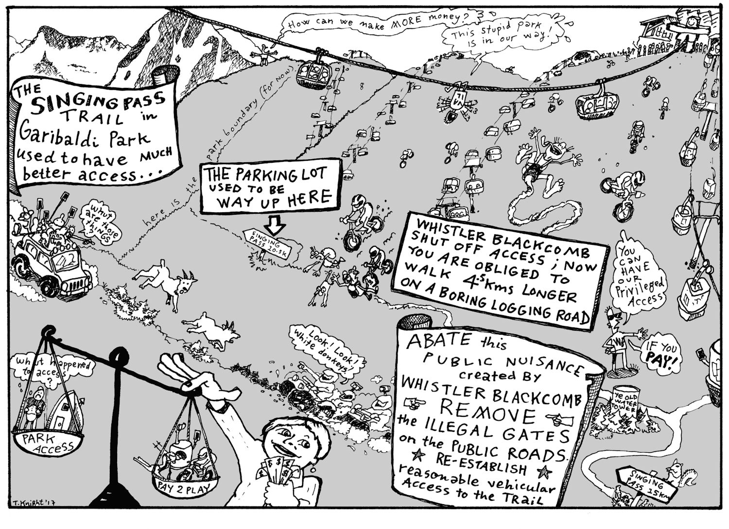
The problem in a nutshell. Government tinkering has granted Whistler Blackcomb 33 km2 of prime alpine terrain in Garibaldi Park. Mountain Resorts Branch is the provincial agency that oversees resort development and approvals for the province. In 2017, the provincial agency approved further expansion of Whistler Blackcomb resort. Meanwhile, the agency ignored binding provisions that would have restored and maintained the public road and parking lot up Fitzsimmons Creek. Park goers now walk an additional 4 or 5 kilometers on a boring logging road with potential hazards before reaching the old parking lot. In another slap in the face, Whistler Blackcomb offers what it calls "privileged access" for $56 per person to use its lift system to access Singing Pass. Christy Clark of the recently defeated provincial Liberal government is tilting the Scales of Justice towards "Pay 2 Play" with her right hand. In her left, Ms. Clark grasps hefty political donations to "party with the premier" as the Globe and Mail newspaper had termed it. Vail Resorts, the new American owner of Whistler Blackcomb, registered lobbyists with Elections BC and those lobbyists made significant donations to the BC Liberals. Further donations came from Whistler Blackcomb, its subsidiary Whistler Heliskiing and Blackcomb Aviation, the heliskiing contractor. The donations are perceived by some as elements of the "cash for access" election issue that helped bring down the Liberal government. Was there political meddling that impaired objective decision-making? That's the innuendo of the cartoon. Now, the New Democratic Party forms government with support of the BC Green Party. Isn't it time to end the political cronyism, backroom deals and perceived culture of cash for favors? Abate what amounts to a public nuisance. Re-establish the public road and parking at the Singing Pass gateway to Garibaldi Park.
How did we get to this impasse?
Read about the human history of Signing Pass access and the complex political and corporate machinations beneath the pleasant veneer of a mountain resort town here Singing Pass Access Summary 1900-2017. The summary chronicles the 40-year long, systematic erosion of park access by a now foreign-owned megacorporation devoted to profit-making and compliant governments beholden to tax dollars. Connect the dots between hefty political donations and government actions or inaction. See large chunks of Garibaldi Park given away 5 or 10 square kilometers at a time to maximize terrain and profit at Whistler Blackcomb. Check for conflict of interest. Watch as public parking and park access withers contrary to binding agreements that would protect it. Marvel how government agencies are compelled to ignore their own policies and master plans and allow park access and infrastructure to deteriorate while tax revenue and private profits increase, massively rewarding insiders and shareholders.
What do we propose?
Support the parking proposal of the B.C. Mountaineering Club. Click here Singing Pass Issue Summary and Parking Proposal to view the full proposal.
What can you do?
Get involved. Write to the Minister of Environment, the Honourable George Heyman. See our talking points here Singing Pass Talking Points.
Issue Lead Advocate - Paul Kubik
Singing Pass Letters Article Count: 5
Singing Pass Parking Proposal Article Count: 7
September 30, 2017
Click image for larger version.
Why is a parking lot needed?
A number of factors show that action on the Singing Pass access issue is urgently needed.
- Huge increases in park visitation in Sea to Sky region. Inadequate parking and trail head infrastructure to accommodate that use.
- Lack of public parking and overnight parking in Whistler. Recent parking bylaws enacted by Resort Municipality of Whistler in July 2017 exacerbate the parking problem for park visitors.
- Imminent construction of four Spearhead huts means increased overnight parking capacity is required. First one at Russet Lake, Singing Pass is scheduled to open in 2019. Construction has begun. People need a secure place to park overnight.
- Existing access road is geologically unstable and access is blocked at Whistler village with a gate. Repairs are reported to be costly.
- Mountain bike terrain park over public road causes safety concerns with hikers.
- Long approach on relatively boring logging road means many park users are unable to enjoy the natural beauty of Garibaldi Park.
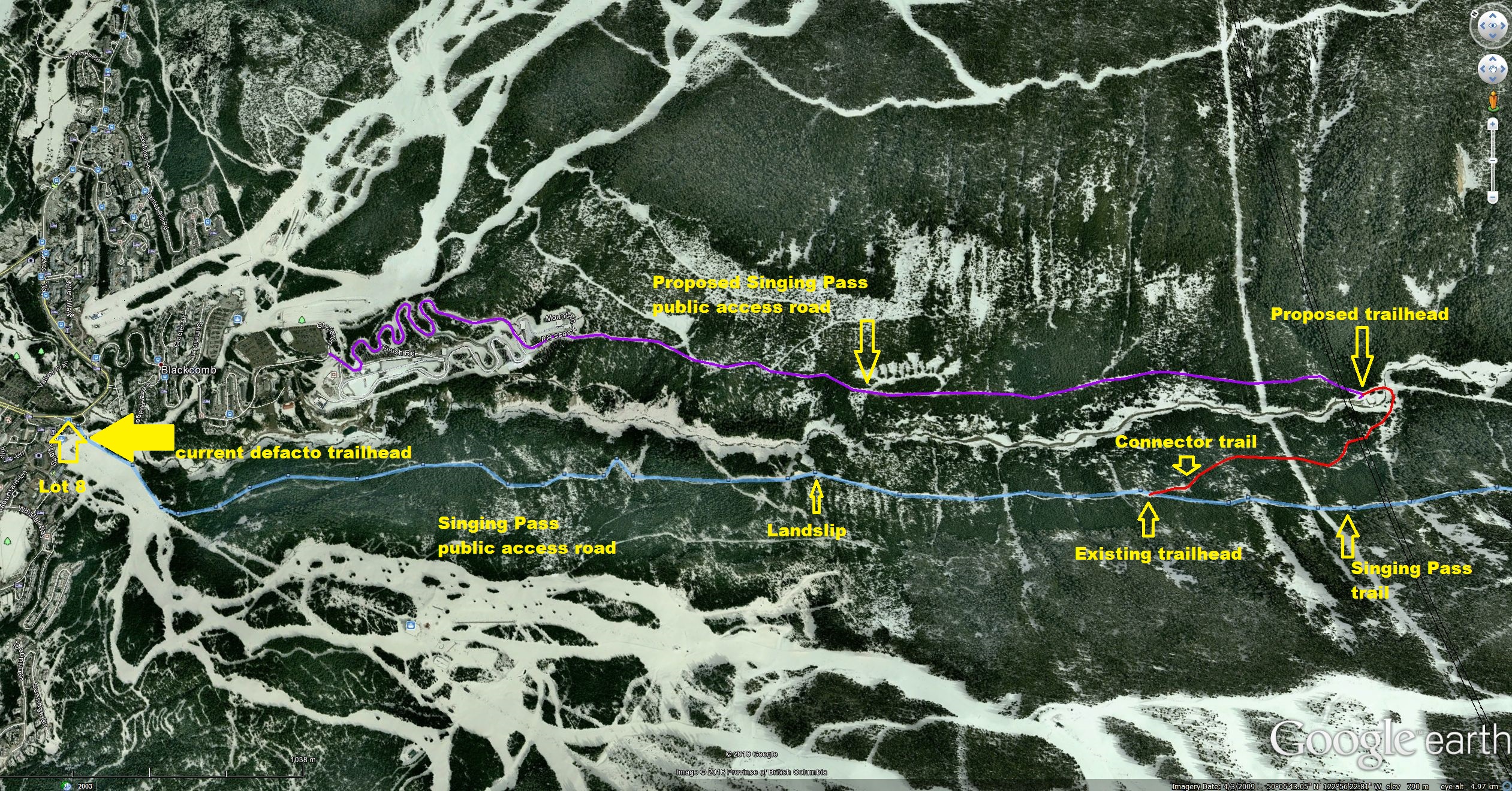
Our proposal
- Work with Whistler Sliding Centre, Whistler Blackcomb and Innergex to obtain private vehicle access to their right-of-ways on the north side of Fitzsimmons Creek.
- Upgrade the industrial road on the north side of Fitzsimmons Creek between the Whistler Sliding Centre and the Innergex independent power project (IPP) intake to allow for private vehicle use.
- Construction of car parking lot at the IPP intake. This is 5 kilometers up Fitzsimmons Creek from Whistler village and adjacent to the park boundary. Actual number of stalls has an upper limit determined by the physical site characteristics. Suggested minimum number of stalls for first year is to be the same as other Garibaldi Park trailheads at Garibaldi Lake, Diamond Head and Cheakamus. Recommended number of stalls should be larger due to current trends in backcountry usage, Whistler's success as a destination resort for outdoor pursuits and construction of the Spearhead huts.
- Build trail head facilities such as washroom, outhouse, lighting, information kiosk, garbage facility.
- Free parking.
- Improved signage from Highway 99.
- New footbridge across Fitzsimmons Creek to connect with existing Singing Pass trail on the south side.
- Clearing the existing, overgrown road between the proposed footbridge and the existing Singing Pass trail.
- Landscaping of parking lot using native species to make it more attractive to visitors and to improve the view from the Peak 2 Peak gondola.
- Fencing of the scrap yard known as the Boneyard to provide security and public safety.
- Regular municipal bus service every hour between 7 AM and 9 PM with 30 minute frequency 9 AM to 5 PM during high summer and during daylight hours for the remaining year May through October.
- Bike storage and/or locking facilities at the trailhead.
- Regular maintenance and patrolling by a facility operator.
- Design work begins in winter 2018. Construction completes summer 2018.
- Updated BC Parks web page.
Additional options to consider
- Widening and paving of the four to five kilometer access road which is currently gravel surface, one lane with pullouts.
- Vehicle bridge at the IPP upstream facility to provide additional parking spaces on the south side of Fitzsimmons Creek.
- Winter snow removal to extend operating season from May through October to year round.
- As the existing IPP road uses the right of way of the Whistler Sliding Centre, due to operational concerns during sliding centre events, the building of a public bypass road around the sliding centre right of way.
- Paid parking (e.g. $5 or $10/day) to be used for maintenance of trailhead services etc.
- Annual pass similar to Northwest Forest Pass in Washington state.
- Reinstate road access through the south side slump area to the original parking lot or create a new parking lot before the slump.
- Relocate the Singing Pass trail to follow Fitzsimmons Creek until Harmony Creek is crossed then ascend to the existing trail east of Harmony Creek. (The existing crossing of Harmony Creek has seriously deteriorated and is now possibly dangerous to use.)
Benefits of the proposal
- Enormously improved hiking experience as more time is spent in Garibaldi Park. It would allow seniors, families with children and the less physically fit to enjoy the beauty of Garibaldi Park instead of trudging up a boring logging road.
- Physically fit people can disperse further into the park.
- Secure day use and overnight parking for park visitors. Costs are potentially offset by a modest day use or overnight parking fee.
- Responsible management of waste and sanitation.
- Opportunity to provide backcountry education and guidelines for visitors by using information kiosks or park attendant.
- Improved public safety as the access road bypasses the unstable landslip on the south side of Fitzsimmons Creek. No conflict with ATV tours and the mountain bike terrain park.
- Consistent with the management direction approved in the 2014 Spearhead Amendment to the Garibaldi Park 1990 Master Plan to improve public access to Garibaldi Park by constructing a public parking facility at the upstream IPP facility.
- The parking lot would serve three trails: (1) Singing Pass trail described here. (2) New connector trail to park trails on the Blackcomb side (Disease Ridge). This trail is mentioned in the park management plan amendment. (3) New Fitzsimmons Creek valley bottom trail.
Challenges
- Agreement from Whistler-Blackcomb to fully support the parking project from the get-go.
- Mountain Resorts Branch has as its own land use operational policy that "Crown land values are managed for the benefit of the public." Encourage Whistler Blackcomb to support the parking project by tying approval of future mountain phase development to its support of the parking project and its continued operation.
- BC Parks to fund the parking lot construction, footbridge and trail clearing in accordance with its approved management direction in the 2014 Spearhead Amendment to the Garibalid Park 1990 Master Plan.
- An agreement with the Whistler Sliding Centre to use their right of way.
- Alternatively, establish a bypass route around the Whistler Sliding Centre right of way.
- Agreement with Innergex to use their right of way. (Innergex in the past has indicated they are willing to allow public use, parking and footbridge construction.)
- Agreement with Resort Municipality of Whistler to provide services to the parking lot such as road maintenance, snow clearing, garbage disposal, sanitation, bus service, landscaping and other maintenance normally provided by municipalities.
Singing Pass Legal Articles Article Count: 3
Singing Pass Meeting Summaries and Minutes Article Count: 6
Singing Pass News Articles Article Count: 5
FMCBC on Singing Pass Article Count: 2
Singing Pass Access Summary 1900 through 2017 Article Count: 1
Singing Pass Talking Points Article Count: 1
Singing Pass Documents Article Count: 3
Skookum Valley / Mamquam Article Count: 10
Issue Lead Advocate - Chris Ludwig
Skookum IPP Documents Article Count: 1
Brohm Ridge / Garibaldi at Squamish Article Count: 18
Whistler Blackcomb / Whistler Heli-Ski Article Count: 18
Whistler Heli-Ski Article Count: 10
Whistler Blackcomb Documents Article Count: 6
Callaghan Lake Region Article Count: 8
Chance Creek Access Article Count: 2
Sea 2 Sky LRMP Article Count: 1
Non motorized zones Article Count: 7
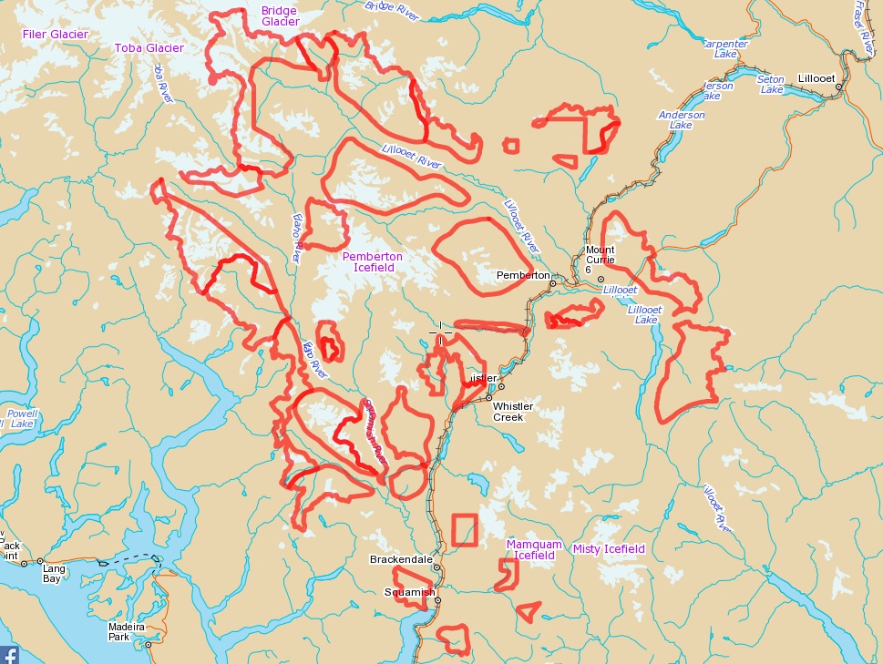
The Sea to Sky Land and Resource Management Plan was adopted in 2008 and specifies a number of non motorized zones that fall under the jurisdiction of the Ministry of Forestry, Lands, and Natural Resource Operations (MFLNRO). The following map specifies the detailed boundaries of these zones.
At the present time most of them have not been implemented with a Section 58 order and therefore not enforcable by the Conservation Office. Negotiations are beginning to get more Section 58s put in place on these zones.
For Gmap Click Here.
Issue Lead Advocate - Bill Maurer
The LRMP identifies the following non-motorized zones:
- Ashlu
- Birkenhead
- Blanca Lakes core
- Cloudburst
- Echo Lake
- Elaho
- Gravell Creek
- Joffre Creek
- Lizzie Creek
- Lower Soo
- Mamquam
- Miller Creek
- Mount Currie
- North Creek
- North Hibachi Ridge
- Phelix Creek west
- Rainbow
- Salal Creek
- Sims
- Sky Pilot
- South Creek
- Sockeye Creek
- Squamish River
- Watersprite
Howe Sound Crest Article Count: 0
Garibaldi Provincial Park Article Count: 12
Garibaldi Provincial Park Documents Article Count: 6
Garibaldi Park General Advocacy Articles Article Count: 4
Tunnel Bluffs Article Count: 4
Lions Bay Article Count: 3
Joffre Lakes Provincial Park Article Count: 8
Mount Meager Article Count: 1
Spearhead Huts Project Article Count: 1
Blackcomb Glacier Provincial Park Article Count: 0
Tenquille Lake Area Article Count: 4
Athelney Pass Area Article Count: 1
Blackcomb Access Corridor Article Count: 1
The latest Blackcomb Master Development Agreement was adopted in 2017 and specifies a dedicated corridor for accessing the Spearhead range from the bottom of the mountain
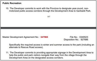
At the present time (Nov 2019) Vail Resorts has not designated a corridor as required by the agreement and Mountain Resorts Branch is not enforcing the public interest specified in the agreement.
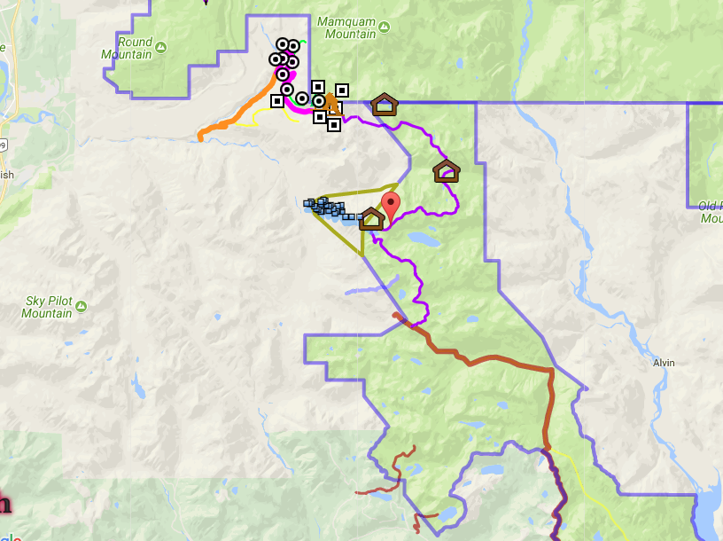
A number of meetings and communications were held between January and July of 2019 to discuss the implementation of such a corridor. It was determined that the safest corridor would go up the Gondola Road and Sunset Blvd runs from the base 2 parking lot to the bottom of 7th Heaven. The groups represented at the meetings were Mountain Resorts Branch of FLNRO, BC Parks, Vail Resorts, and a number of stakeholders. It became apparent fairly quickly that no substantive changes were being made to establish such a corridor in time for the 2019/2020 ski season.
Until Mountain Resorts Branch and/or Vail Resorts designates a corridor as the MDA requires we are recommending uphill travel via Gondola Road and Sunset Blvd. These runs are the least impacted by avalanche clearing operations, are low angle green runs, and have very good site lines for both uphill and downhill traffic. You generally access the Spearhead by travelling SE from the bottom of the 7th Heaven lift and up the valley between Blackcomb and Decker. We have provided a map and downloadable track of the corridor below.
This can be used for day access to Blackcomb, Spearhead, Decker, Phalanx, Trorey, Pattison, Tremor, and Shudder mountains. This is one of the most spectacular backcountry ski areas in Garibaldi Park. It takes approximately 2.5 hours to reach the base of 7th via this approach. I have included supporting letters and documentation of the negotiations that have occurred to this point. See photo albums of the various objectives that are possible in this area. They were all done as day trips.
Issue Lead Advocate - Bill Maurer
2019-01-22 Blackcomb Ski Patrol claiming no uphill travel allowed through CRA
2019-01-25 Letter to Mountain Resorts Branch and BC Parks requesting corridor
2019-03-27 Meeting invitation from Mountain Resorts Branch
2019-04-24 Meeting Minutes
2019-05-04 Trip to Trorey
2019-06-14 Meeting Request
2019-06-18 Letter to Working Group expressing frustration at lack of progress
2019-07-04 Notice of cancellation of working group by Mountain Resorts Branch
2019-11-18 Letter to MRB requesting status of corridor discussions with Vail
2019-11-28 Pique - Uphill Battle
2019-12-05 Pique - Action will speak lourder than words
- Min Elevation
- 750 m
- Total Distance
- 8.87 km
- Max Elevation
- 1722 m
- Way Points
- 0
- Total Elevation Gain
- 988 m
- Track Points
- 648
- Total Elevation Loss
- 22 m
| Values not available in the file may shown as 0. | |||
|
This track was downloaded 16 time(s). Please register/login to download this track. |
Sea to Sky Gondola Article Count: 3
Rubble Creek and Garibaldi Lake Article Count: 3
Woodfibre and Mount Sedgwick Article Count: 1
Nlháxten/Cerise Creek Conservancy Article Count: 3
Lake Lovely Water Article Count: 3
Roe Creek FSR Article Count: 1
Meager Creek Hotsprings Article Count: 1
Fraser Valley Article Count: 20
Bridal Falls Gondola Article Count: 4
Golden Ears Provincial Park Article Count: 2
Davis Lake Article Count: 1
Pinecone Burke Provincial Park Article Count: 8
Backcountry BC and the BC Mountaineering Club have made a prosposal to BC Parks to allow for several new trails for Pinecone Burke Provincial Park. The proposal included the provision of several backcountry huts, for discussion as possiblities. The first draft of the park master plan for Pinecone Burke is being prepared by BC Parks. As of March 2020, the draft plan has still not been released. For more detailed mapping of the proposed trail and huts, click Pinecone Burke Proposed Trails. More information about Pinecone Burke Park and the proposal can be found in the categories listed below.
Lead Advocates: Paul Kubik and Chris Ludwig
Pinecone Burke Park Historical Article Count: 1
Pinecone Provincial Park Master Plan 2018 Article Count: 1
Widgeon Marsh Article Count: 2
Buntzen Lake Article Count: 1
Vedder Mountain Article Count: 1
Lexw Qwo:m Park Article Count: 1
Coquihalla / Manning Article Count: 13
Coquihalla Summit Recreation Area Article Count: 2
Manning Park Article Count: 1
Manning Park Donut Hole Article Count: 10
Princess Louisa Inlet Article Count: 1
Princess Louisa Property Article Count: 1
Squamish Rock Climbing Article Count: 6
Murrin Park Article Count: 1
Smoke Bluffs Article Count: 5
North Coast / Nechako Article Count: 0
Northeast Article Count: 0
Province Wide Article Count: 78
Environment Article Count: 15
Mountain Goat Documents Article Count: 3
Mountain Caribou Article Count: 2
Old Growth Forests Article Count: 3
Bears Article Count: 2
Climate Change Article Count: 4
Wolves Article Count: 1
Government Reports and Documents Article Count: 7
Government Reports Article Count: 1
Provincial Budgets Article Count: 1
Freedom of Information Article Count: 1