- You are here:
-
Home

-
Maps and Media
-
Custom Maps
-
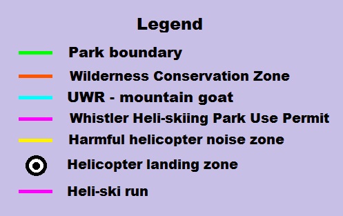
Spearhead Heli-skiing Custom Map
-
Issues
-
Mainland / Southwest
-
Coquihalla / Manning
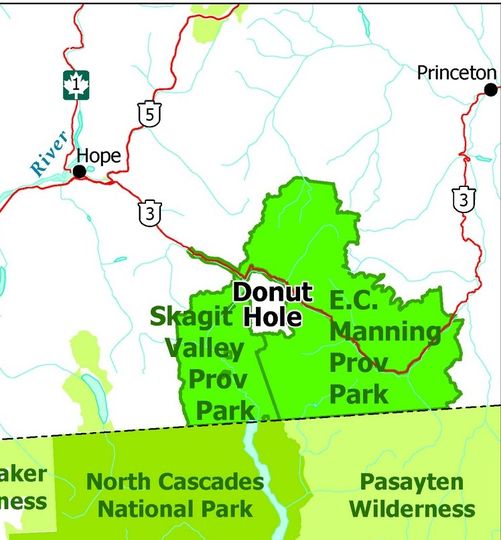
- Manning Park Donut Hole
Manning Park Donut Hole
No more logging in the Skagit-Manning donut hole.
"To protect the environment for people now and in the future, the B.C. government has taken steps to safeguard the Silverdaisy watershed from logging on the B.C. side of the Skagit River Valley.
“Effective immediately, BC Timber Sales will no longer award timber licences in the Silverdaisy area, ensuring no additional commercial forest harvesting occurs in that area,” said Doug Donaldson, Minister of Forests, Lands, Natural Resource Operations and Rural Development. “We’ve heard loud and clear from individuals and groups on both sides of the border that logging should stop in the Silverdaisy, and we’re making sure that commercial timber harvesting in that area does not continue.”
The Silverdaisy management area – commonly known as the “Donut Hole” – is about 5,800 hectares. It consists of lands removed from the original Skagit Valley Recreation Area in 1995, Skagit Provincial Forest and lands removed from E. C. Manning Park in 1968. These lands are adjacent to one another and are surrounded by both Skagit Valley Park and E. C. Manning Park."
Full Article:
Letter to the Skagit Environmental Endowment Commission from conservation, recreation and wildlife organizations expressing and reinforcing the strong opposition to any and all resource extraction activities in the headwaters of the Skagit River, inclusive of both the British Columbia Timber Sales (BCTS) proposed block and road development in the Upper Skagit River drainage (Silverdaisy and Twenty-Six Mile Creeks) and this subsequent mineral exploration permit application which has been enabled by the roading work initiated by prior BCTS activities.
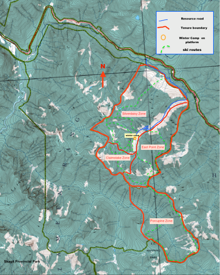
Another Day, another 15 KM2/1,852 Hectare adventure tourism/commercial recreation permit application (including a Yurt) at Silverdaisy Mountain (see and submit comments on the application at the following link).
I have never been a traditional "tree hugger" conservationist type and have always believed that there should be a balance between public recreation, commercial operations and pure conservation. In light of all of the recent commercial land applications/tenures, I am starting to ask the question "what happens if we run out of land?". I also wonder and question my own concept and notion of what constitutes "Wilderness", and in fact do we have much if any "Wilderness" left anymore.
-x-
The Application: (June 8, 2018)
Client: Berntsen Enterprises Limited
Purpose: COMMERCIAL RECREATION/MULTIPLE USE
Region: Lower Mainland, Surrey
Agency: Crown Land Allocation
File: #2411996
Location: Silverdaisy Mountain
Area (Hectares): 1,852.09 ha +-
BCGS Mapsheet: 92H015 92H 016
Legal Description: see below
Legal Description: THAT PART OF DL1584, BEING A.M. NO. 4 MINERAL CLAIM, DL533, BEING VERNON 4 MINERAL CLAIM, DL1586, BEING A.M. MINERAL CLAIM, DL1587, BEING A.M. NO. 2 MINERAL CLAIM, DL1577, BEING A.M. NO. 3 MINERAL CLAIM, DL1585, BEING AUGUSTUS NO. 5 FRACTION MINERAL CLAIM TOGETHER WITH THAT PARCEL OR TRACT OF LAND IN THE VICINITY OF SILVERDAISY MOUNTAIN, YDYD
The tenure application is approximately 15 square kilometers. Vehicle access is from Highway 3, 38 km east of Hope, at a pullout and parking area, called Cayuse Flats. The trail access to the area is along a resource road through a corridor of Manning Provincial Park. The road generally follows the Manning Park boundary for approximately 3.5kms, after which the road moves entirely into crown land.
The project is considered for extensive use and consists of installing a temporary structure that would provide passing accommodation for recreational users in the surrounding area and for using existing trails and resource roads for recreation activities. In winter and summer seasons, self-propelled activities such as ski touring, snowshoeing, avalanche training, hiking and possibly mountain biking are being proposed. The winter season occurring from January to March the summer season from July to September. If users? response is positive building a cabin in the future may be an option in which case the cabin construction will fall under intensive use and will require an amendment to the existing use if authorized.
Please refer to Management Plan and Appendices for detailed information: https://arfd.gov.bc.ca/ApplicationPosting/viewpost.jsp?PostID=55391&fbclid=IwAR0tmrNOKrP9R2bZqKwSfLhRgzBNLwEDEZl4SMJt0dyVZStxplwmP5k9oFg