Mamquam Mountain - 2588 meters/8491 feet - Location: 49.77528, - 122.85083
 Mamquam Mountain is the highpoint of the sprawling Mamquam Icefield massif in southern Garibaldi Provincial Park. The approach is fairly long and is often done on skis via Skookum Creek or Elfin Lakes. The standard summit route is along the easy northwest ridge. "Many parties routinely fail to climb this summit" according to Anders Ourom in the Fairley guide. It was first climbed in 1911 by B. Gray, C. Chapman, H. Korten, F. Perry and F. Smith.
Mamquam Mountain has long been a coveted ascent for Mountaineers due to its extensive icefields, and its remote and aesthetic nature. Until recently, its ascent was long and difficult due to access difficulties and extensve coast mountain bush. The completion of the Skookum Independant Power Project and the clearing of Kilometers of old overgrown logging roads by members of the 2020 team (and many others) has vastly simplified and improved access to this impressive and beautiful mountain.
Mamquam Mountain and its surrounding glaciers can be viewed from many points in the city of Vancouver, British Columbia including the Tsawwassen Ferry Terminal, Highway 17a, and the Squamish River Estuary.
Backcountry BC Mamquam Photo Galleries:
Backcountry BC Mamquam Mountain Photo Gallery: Photo Galleries
Darling Lake Trail (Mamquam) Photo Gallery: Photo Galleries
The Backcountry BC website features extensive Mapping of Mamquam Mountain which can be accessed at the following internal links:
Mamquam Custom Map:
Mamquam Custom Map
Skookum RA1 Non-Motorized Boundary Map
- Min Elevation
- 0 m
- Total Distance
- 22.02 km
- Max Elevation
- 0 m
- Way Points
- 0
- Total Elevation Gain
- 0 m
- Track Points
- 28
- Total Elevation Loss
- 0 m
| Values not available in the file may shown as 0. | |||
|
This track was downloaded 3 time(s). Please register/login to download this track. |
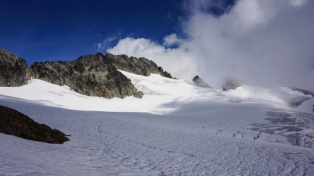
The summit of Mamquam Mountain as seen from the vast Mamquam Icefield: