
- You are here:
-
Home

-
Issues
-
Mainland / Southwest
-
Sea to Sky
-
Garibaldi Provincial Park
- Garibaldi Park General Advocacy Articles
Garibaldi Park General Advocacy Articles
The "five trailheads" of Garibaldi Park
- Written by Chris Ludwig
- Hits: 5864
BC Parks Managers have an unspoken and unpublicized policy of concentrating (limiting) non-mechanized access to Garibaldi Park to the "5 Trailheads". At 2020, we often refer to these as the "4 1/2 trailheads" because one of the five is the Singing Pass Trail. See: http://backcountrybc.ca/index.php/24-issues/swbc/s2s/singing-pass-issues/70-singing-pass-trail-fiasco
The BC Parks policy of limiting access to the 5 trailheads is not mentioned anywhere in the Garibaldi Park 1990 Master Plan, and nor is it mentioned in any of the documents and letters by the Park Founders:
Simply put, we believe in the vision of the Park Founders - Garibaldi Park was intended to be unrestricted to the non-mechanized user with no commercial operators and intrusions, have permanent boundaries, and BC Parks was to focus on promoting and expanding a high quality network of hiking trails.
After reading through the evidence presented on the 2020 site, it is clear that the BC Parks of today has deviated enourmously from the vision of the park founders.
About Mamquam Mountain
- Written by Chris Ludwig
- Hits: 9039
Mamquam Mountain - 2588 meters/8491 feet - Location: 49.77528, - 122.85083
 Mamquam Mountain is the highpoint of the sprawling Mamquam Icefield massif in southern Garibaldi Provincial Park. The approach is fairly long and is often done on skis via Skookum Creek or Elfin Lakes. The standard summit route is along the easy northwest ridge. "Many parties routinely fail to climb this summit" according to Anders Ourom in the Fairley guide. It was first climbed in 1911 by B. Gray, C. Chapman, H. Korten, F. Perry and F. Smith.
Mamquam Mountain has long been a coveted ascent for Mountaineers due to its extensive icefields, and its remote and aesthetic nature. Until recently, its ascent was long and difficult due to access difficulties and extensve coast mountain bush. The completion of the Skookum Independant Power Project and the clearing of Kilometers of old overgrown logging roads by members of the 2020 team (and many others) has vastly simplified and improved access to this impressive and beautiful mountain.
Mamquam Mountain and its surrounding glaciers can be viewed from many points in the city of Vancouver, British Columbia including the Tsawwassen Ferry Terminal, Highway 17a, and the Squamish River Estuary.
Backcountry BC Mamquam Photo Galleries:
Backcountry BC Mamquam Mountain Photo Gallery: Photo Galleries
Darling Lake Trail (Mamquam) Photo Gallery: Photo Galleries
The Backcountry BC website features extensive Mapping of Mamquam Mountain which can be accessed at the following internal links:
Mamquam Custom Map:
Mamquam Custom Map
Skookum RA1 Non-Motorized Boundary Map
- Min Elevation
- 0 m
- Total Distance
- 22.02 km
- Max Elevation
- 0 m
- Way Points
- 0
- Total Elevation Gain
- 0 m
- Track Points
- 28
- Total Elevation Loss
- 0 m
| Values not available in the file may shown as 0. | |||
|
This track was downloaded 3 time(s). Please register/login to download this track. |
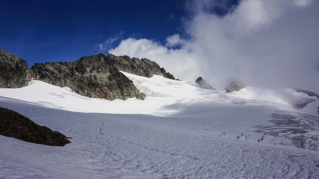
The summit of Mamquam Mountain as seen from the vast Mamquam Icefield:
About Garibaldi Park
- Written by Chris Ludwig
- Hits: 6773
Garibaldi Park - A Basic Description from Wikipedia
Garibaldi Provincial Park, also called Garibaldi Park, is a wilderness park located in British Columbia, Canada, about 70 kilometres (43.5 mi) north of Vancouver. The park is located to the east of the Sea to Sky Highway between Squamish and Whistler and covers an area of over 1,950 square kilometres (753 sq mi). Garibaldi was designated as a provincial park in 1927, and originally included what was later split off in 1967 as Golden Ears Provincial Park,which juts southward between the basins of Pitt Lake and the Stave River into the Municipality of Maple Ridge.
The park consists of many steep, rugged mountains, many of them capped by glaciers. It includes Mount Garibaldi and other volcanoes related to subduction volcanism in the Garibaldi Volcanic Belt. The park features many dense Douglas-fir, western red cedar and western-hemlock forests, as well as alpine meadows and many rocky alpine areas. The park reaches its highest peak at Wedge Mountain—2,891 metres (9,485 ft).
Explore Garibaldi Park using Garibaldipark2020.com's mapping engines:
This is the Garibaldi Provincial Park boundary from Open Street Map. The waypoint density is thickened to 200 meters.
Option 1 - Click Here for Gmap Rendering (use this option if map below fails to display)
Option 2 - Garibaldipark2020's two internal mapping engines (the maps below):
(Click on the blue "plus box" on the upper right of the map below to select a different map type. The zoom function and full screen option is found on the upper left of the map below)
{gpxtrackmap}GaribaldiParkBoundaryOSM200m.gpx{/gpxtrackmap}
Garibaldi Park 2020 OSM Mapping Engine
Open the Master Plan - The Original Garibaldi Park 2020 Vision
- Written by Chris Ludwig
- Hits: 7569
Do you concur with the mission statement of the Outdoor Recreation Council?
Promoting access to and responsible use of BC's public lands and waters for public outdoor recreation
We do.
We restored access to the heritage Darling Lake Trail in 2015. It is an existing trail in a lawfully recognized backcountry recreation corridor. It would seem uncontroversial and beneficial to public outdoor recreation. Instead, our efforts stirred a hornet’s nest starting with BC Parks, particularly the Lower Mainland Region and Squamish/Sea to Sky District offices. In the analogy, they immediately went into attack mode by bringing in Compliance and Enforcement officers to issue ludicrous stop work orders containing factual errors and threats of jail time and heavy fines. Dialogue did not seem to be an option. Clearly, something is seriously wrong and it is not heritage trail restoration efforts.
We are laying out the case to reopen the Garibaldi Park Master Plan by the year 2020. We see it as the only option available to restore backcountry access and issue a rebuke of park managment practices and provincial government interference.
By 2020, it will be 30 years since the Garibaldi Park 1990 Master Plan was approved. The master plan had a term of five years, which expired in 1995. An amendment was approved for the Spearhead area in 2014. Squamish, Whistler and Pemberton have developed as recreation meccas and Garibaldi Park is on their doorstep. Recreation demand from the Vancouver region has dramatically increased in 30 years. It is time for a new master plan that reflects present day realities of recreation demand. It is also overdue to address the encroachment of commercial interests and development on Garibaldi Park's western flank. It is also time to take aim at the gross interference by the provincial government in park management.
What started as a trail restoration project has grown to address grievances of a multitude of backcountry recreationists and outdoor groups – grievances that have been simmering for at least the last decade. Garibaldi Park 2020 web site is home to a fact-based, science-based and widely democratic organization seeking a massive overhaul of the park master plan and rebuke of paternalistic, condescending and unscientific park management practices. Rebalancing is required.
Somewhere along the way, park managers lost their connection to the original principles that guided the formation of Garibaldi Park by park founders. Park managers since 1990 became the agents for commercial interests advancing their business models at the expense of park land. There is heli-skiing in the Spearhead, removal of park land for commercial ski development, ceding Singing Pass trailhead access to Whistler-Blackcomb for bike parks and ATV racing or standing silently by while extravagant real estate developments are promoted up to the park boundary at Brohm Ridge. We find that park managers either through their actions or inaction obstruct and deny access to backcountry areas of the park. The current park master plan does not sanction restricting access nor does it put specific limits on park usage. The use of terms such as “low to moderate use” is ambiguous, depends on the frame of reference of the reader and in no way justifies limiting recreation opportunities.
Park deletions since 1966 are numerous. Park users may today be hiking a trail or climbing a mountain that tomorrow is carved out of the park and given away to commercial enterprises. Think of Blackcomb Glacier and Mount Garibaldi. The decisions are made behind closed doors of provincial cabinet for the benefit of the real estate and ski industries. We must prevent the government treating the park as a land bank from which withdrawals can be made whenever a new profit scheme crops up.
Meanwhile, park managers make inconsistent decisions on wildlife matters over different areas of the park. It’s okay to fly helicopters, develop snowmobile and hiking trails, massive ski areas, real estate developments and cabins right next to mountain goat winter range in the Spearhead Range and Brohm Ridge. But the presence of a hiking trail no closer than 350 meters to mountain goat winter range on the steep western edge of Darling Ridge brings out the C&E officers getting heavy with the BCMC for alleged, scientifically unsupportable impacts on goats. The decisions made on wildlife matters or lack thereof, is inconsistent with their own science-based policy papers. On the contrary, they extend heli-skiing permits, support park deletions and ignore the advice of their own studies on how to protect mountain goats from mechanized activity. There is no one in BC Parks standing up to prevent the extirpation of mountain goats and grizzly bears in the Spearhead Range and Brohm Ridge from egregious commercial development. Obviously, money talks when your friends are in the real estate and ski industries.
The 1990 park master plan is clearly deficient in not recognizing the importance of the heritage Darling Lake Trail. The Sea-to-Sky Land and Resource Management Plan of April 2008 does. It recognizes the important backcountry corridor through which the trail runs towards Darling Lake and Mamquam Icefield. When the park master plan was created in 1990, road access was still in place up Skookum Creek and the trail easily accessible with a footbridge across East Fork Skookum Creek. The use of road and trail was widely accepted as a backcountry access corridor even before its lawful designation. No one in 1990 expected BC Parks to obstruct and deny access to the trail and Mamquam Icefield and nor did they obstruct access at that time. Thus it was a great surprise to the outdoor community in 2015 when BC Parks chose to do so. It was a serious planning error in 1990 to place Mamquam Icefield under wilderness rather than natural environment zoning. The error is used today to justify obstructive actions that are not sanctioned in the master plan. The parks service has crossed the line with these actions, a line beyond which there is no legal basis.
How will new trails be paid for?
Garibaldi Park 2020 is suggesting no new monies are required to fund the ambitious trail development plan. Mountain clubs are already managing trail development in the Esté-tiwilh/Sigurd Creek Conservancy and Tantalus Provincial Park. (Esté-tiwilh is pronounced us-tut-ee-wayth.) Since 1990, mountain clubs have managed and extended the original trapper's trail for 7 kilometers from Ashlu River to the west ridge of Ossa Mountain. Grants over the span of three years totalling about $7,000 have been awarded for footbridge replacement and trail development. Over the course of 25 years, the trail has benefited from approximately 300 days of volunteer effort just on Sigurd and Rose Trails in the Sigurd conservancy. It is a very successful model that can be applied to the heritage Darling Lake Trail and any other trails in the proposal.
Rebalance the Garibaldi Park 1990 Master Plan
|
|
|
|
|
|
|
|