
From Alex Wallace of the Federation of Mountain Clubs of B.C.
I have attached a photo from Feb 27th of the encroachment on the Hikers Access Trail on Hollyburn: I heard from a few people expressing their annoyance at this, and I hear that Lesley Bohm raised it at FMCBC Rec and Con in February.
It looks to me very much like the ski area took advantage of the two years of (inexplicable) work by the BC Hydro contractor, i.e. the extensive blasting and earthmoving in the Fall of 2017 and 2018, to double the number of ski runs on the Powerline this winter. When I asked Russell Chamberlain [of Cypress Mountain Resort] about BC Hydro contractor and their rerouting of roads last fall when we were reviewing the parking lot work last summer, he claimed to have no connection with it or BC Hydro’s contractor (...although his crew would have had to allow the machinery and trucks in and out of the CRA chain gate.) However, on the face of it, the improvements by BC Hydro to the Powerline road by unnecessarily doubling it in this area and blasting away any rock knolls were exactly those needed in the way of ski run improvements, so in my view there would appear to be a clear connection.
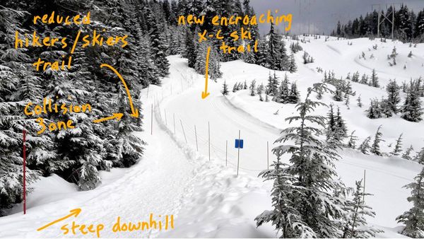
This is the back of the little knoll at the top of the Powerline Hill just before you cross between Second and Third Lakes and start ascending Hollyburn towards Triangle Lake. It needs to be wide here as skiers are descending and snowshoers could be ascending - and the conditions are not always perfect [like this week.] The new ski run obliterates the Hikers Access Trail which was cut to 20ft (6m.) by Ranger Jim Wigmore as proposed by BCMC in 1986, and which is now reduced to roughly 1m. in width - plus on the right is where we previously had a ‘return trip’ easier grade trail for returning skiers and snowshoers, so they did not have to ascend the knoll - i.e. this separated the up & down traffic on the steepest part. This is now a new a Groomed Nordic ski run which is 20ft wide, i.e. which is what I recall the Hikers Access Trail was determined to be by the Cypress Park Master Plan from 1986 onward, however I can’t find the paragraph or map that I am looking for, stating that it was to be 20f wide and not to be groomed. It is defined to be outside the CRA, so I need to look for the CRA boundary map- however the ones I have are not exactly accurate...
The 1997 Master Plan includes the wording “Action: Repair and relocate the most difficult spots of the Hikers’ Access trail to provide greater user safety and enhance their aesthetic experience.” This was in response to Lesley Bohm’s complaint in 1995 that the upper Hikers Access Trail switchbacks on the Powerline hill were too steep, particularly in icy conditions, and should be relocated 50m. SW to the less steep slope: the current ‘expanded’ Nordic Trail shown here uses this slope, and utilising the new ski run (on the right of the photo) so using this as a new and less steep Hikers Access alignment would be a good start to implementing the Action item in the 1997 Master Plan, Pg 54.