Public safety lacking on Hollyburn backcountry route
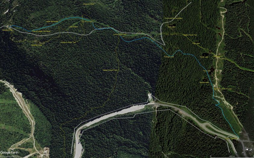
The map shows the public winter route to Hollyburn summit. Used by backcountry skiers, snowshoers, hikers and dogs the route's popularity puts people at risk of injury. Add in the COVID-19 recommendation for physical separation and there is simply not enough room at the bottlenecks to meet provincial guidelines meant to prevent viral transmission.
It used to be manageable to ski down the route without concern. That's long ago. Snowshoeing took off as a sport. Heavy use by slower traffic both up and down creates hazards for everyone, especially on steeper pitches, coupled with crappy snow conditions and bottlenecks. Portions of the trail, such as between Triangle Lake and the Baden-Powell junction, see uphill and downhill traffic confined to a narrow one-meter wide trail.
The portion of the narrow, steep pitch down from the summit to Upper Romstad is often heavily trenched by sliders.
Multiple pinch points and blind spots on the trail mean outbound skiers surprise slow traffic, often spread out or standing in groups.
The steep switchbacks above the parking lot are another choke point. The schuss below the switchbacks is often congested with people stopped in groups spreading out and families with children looking for snow play.

- You are here:
-
Home

-
Issues
-
Mainland / Southwest
-
North Shore
-
Cypress Provincial Park
- Public safety lacking on Hollyburn backcountry route
Public safety lacking on Hollyburn backcountry route
- Written by Paul Kubik
- Hits: 4106