
- You are here:
-
Home

-
Issues
-
Mainland / Southwest
-
North Shore
- Cypress Provincial Park
Cypress Provincial Park
Public safety lacking on Hollyburn backcountry route
- Written by Paul Kubik
- Hits: 4035
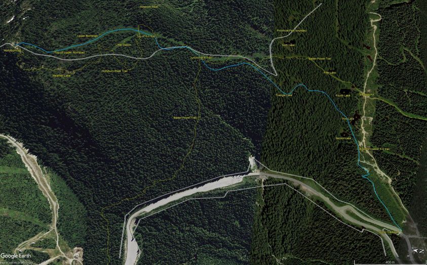
Public safety lacking on Hollyburn backcountry route
The map shows the public winter route to Hollyburn summit. Used by backcountry skiers, snowshoers, hikers and dogs the route's popularity puts people at risk of injury. Add in the COVID-19 recommendation for physical separation and there is simply not enough room at the bottlenecks to meet provincial guidelines meant to prevent viral transmission.
It used to be manageable to ski down the route without concern. That's long ago. Snowshoeing took off as a sport. Heavy use by slower traffic both up and down creates hazards for everyone, especially on steeper pitches, coupled with crappy snow conditions and bottlenecks. Portions of the trail, such as between Triangle Lake and the Baden-Powell junction, see uphill and downhill traffic confined to a narrow one-meter wide trail.
The portion of the narrow, steep pitch down from the summit to Upper Romstad is often heavily trenched by sliders.
Multiple pinch points and blind spots on the trail mean outbound skiers surprise slow traffic, often spread out or standing in groups.
The steep switchbacks above the parking lot are another choke point. The schuss below the switchbacks is often congested with people stopped in groups spreading out and families with children looking for snow play.
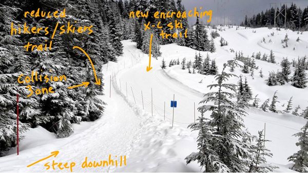
Encroachment on the Hikers Access Trail on Hollyburn
- Written by Paul Kubik
- Hits: 4040
Cypress Park road clearing contract timeline
- Written by Paul Kubik
- Hits: 5244
November 19, 2017
The FOI package TRA-2016-65250 is the source of a lot of the information presented in the road clearing contract (the RCC) timeline.
September 13, 1984 Original road clearing contract.
November 5, 1986 First modification to road clearing contract. Cypress Road Clearing Contract (1986)
August 26, 1991 Cypress Bowl Road is transferred from Ministry of Lands and Parks to Ministry of Transportation and Highways. Memorandum of Understanding between MLP and MoTH (1991)
February 27, 1998 The second modification to the road clearing agreement. The RCC is amended to replace sections 14.01, 14.03 and 14.06. Basically, it appears to be new formulae for calculating amounts payable.
January 23, 1992 Cypress Bowl Road is classified as "Arterial Highway" by Order in Council no. 116. An arterial highway is defined by the Ministry of Transportation as a provincial road within a municipality. According to the Highway Act, section 30(1) The control of the construction and maintenance of every arterial highway is vested in the ministry. Order in Council No. 116 (1992)
March 15, 2004 The third modification to the road clearing agreement. The RCC is amended to replace the formulae for calculating amounts payable with a fixed rate of $510,000 adjusted annually for the CPI. Memorandum of Understanding CBRL road clearing (2004)
October 5, 2011 Letter confirming Cypress Bowl Road continues to be classified as "Arterial Highway". Letter confirming arterial status for Cypress Bowl Road (2011)
March 25, 2014 Letter speculating about an abandoned gate house. The Superintendant, Roads of West Vancouver states that it should have been permitted by Ministry of Transportation and Infrastructure. Abandoned gate house (2014)
February, 2017 Cypress Mountain Resort moves its gate house on Cypress Bowl Road from the West Vancouver Municipal Works Yard to the intersection with Chippendale Road. Permit for sign, erection or obstruction on Cypress Bowl Road by Cypress Mountain Resort According to the Highway Act, section 32(1)(c) a person must not place a sign, erection or obstruction on an arterial highway, except with the consent of the minister and after having obtained from the minister a permit in writing...
Cypress Mountain ‘dawn patrol’ dispute not definitively resolved
- Written by Paul Kubik
- Hits: 5639
November 18, 2017
An article in the North Shore News, Cypress Mountain 'dawn patrol' dispute resolved, prompted the following letter to the newspaper.
The British Columbia Mountaineering Club is one of the specific mountaineering group that requires early access to Cypress Bowl. A 9 AM opening of the backcountry access corridor placed a huge risk on ski mountaineering parties skiing to Lions Bay along the Howe Sound Crest. An early start is necessary in winter due to the short days and an increased avalanche risk on west-facing slopes during the descent later in the day.
I spoke with former Cypress Mountain Resort GM, Bobby Swain last winter to explain the risks we faced. Mr. Swain said early arrivals were taking prime parking spots and poaching ski runs. I wrote to Assistant Deputy Mininster Jim Standen of BC Parks and he alleged the issue was about safely crossing through the backcountry access corridor, which is wide open and well lit. If we discard Mr. Standen's arguments as being uninformed due to his being a remote mandarin in Victoria, the issue is solely about operational concerns of the resort such as parking and poaching. If Mr. Standen was informed and concerned with public safety he would have realized the safety risk placed on ski mountaineers was unacceptable.
The park master plan talks of year-round public access both to the park and up Cypress Bowl Road. It is the road that is closed until 7 AM and misconstrued by many that the park is closed. The closure incidentally prevents people from access to West Vancouver Upper Lands . The B.C.M.C. is looking into reducing or eliminating the road closure. We are the best judges of when our trips should start. Ministry of Transportation Infrastructure contracts snow clearing to CMR, stipulating the hours of operation are between 7 AM and 11 PM and that's the reason given for closing the road outside those hours. However, there is at least one irregularity such that CMR employees and private cabin owners drive the closed road. It highlights that the road closure is not about public safety in driving a highway but about protecting CMR assets. This is the curious nature of dialogue that is conducted in double-speak.
After all, on warm days in winter or in spring when days are longer and generally warm, there is no threat to public safety in driving the road. Like most competent drivers on the Sea to Sky highway to Whistler, ski mountaineers are insured and our vehicles are winterized.
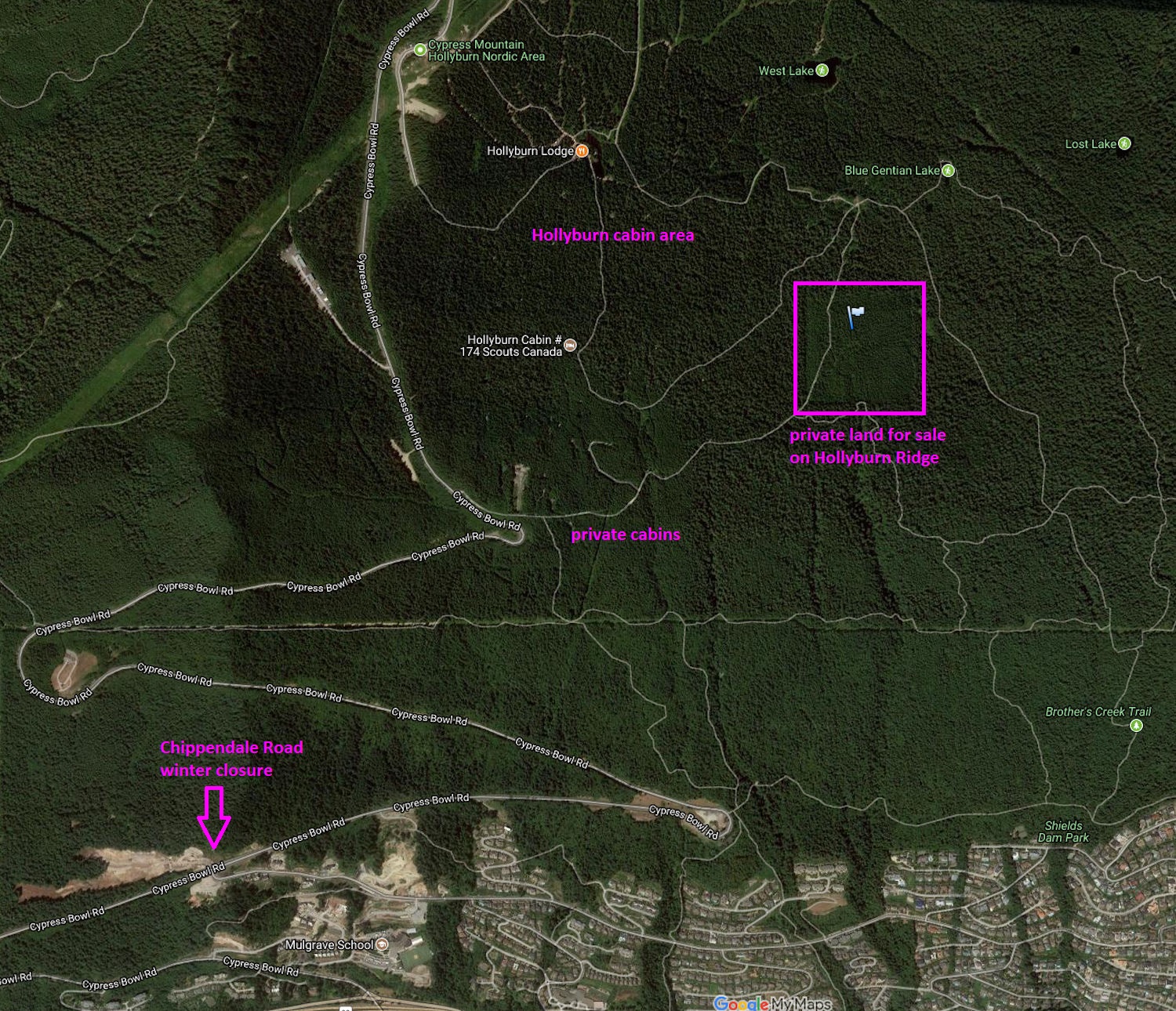
Solution to the winter road closure: buy private land on Hollyburn Ridge
- Written by Paul Kubik
- Hits: 9603
August 14, 2010
Vancouver Sun article by Derrick Penner.
Your West Vancouver private hideaway? Only $1.8 million
Perched on Hollyburn Ridge, overlooking the city, is a patch of mountain forest that could be someone’s private preserve.
The 10-hectare square, located a kilometre by logging road off the Cypress Bowl Road, is on the market for $1.8 million.
However, anyone thinking it is a bargain, given its location, will have to stop and imagine it more as a rustic park than posh estate, owing to its curious community-use zoning with the District of West Vancouver.
“You can put a cabin on it and have your own retreat,” realtor Annette Denk said of the picturesque property.
Denk said West Vancouver allows minimum two-hectare parcels within the zone, so the lot could be subdivided “and you can put a whole bunch of cabins on it.”
It was logged once a little over 40 years ago, but the forest has grown back and Denk said traversing its trails “is just like walking through your own park.”
That’s exactly how members of the family that owns it use the lot now. They don’t have any type of home on it.
“We go up there for hikes and stuff like that, have picnics,” Tony Michaud said.
“It’s all view property. You used to be able to stand in the middle and look out to Mount Baker, and to your left, you could see the Grouse Nest [restaurant].”
The trees have grown in considerably since, but Michaud said the views are still stunning, and it is only 30 minutes from downtown.
Michaud’s father Charles bought the land in the 1960s when it was known as Hudson’s Estate and logged it around 1968, he said.
Michaud said his father worked in logging camps before starting a crane company on the North Shore, so he knew what kind of value the trees had for timber.
“He got a lot of timber off the property,” he said.
Charles Michaud died in 1986, Michaud said, and his mother Irene died in 1997.
Over the years the family has considered selling. Tony said the District of West Vancouver even expressed some interest once in purchasing the property, but did not do so in the end.
Brent Leigh, West Vancouver’s deputy CEO, said the Michaud property is the largest single property in what is a popular recreational area.
Above it, there are numerous small lots available for private purchase, and the 100 or so historic Hollyburn cabins that are owned by the district and leased to users.
Leigh said the district is developing a parks master plan to develop a community vision for the region.
But Tony Michaud, his brother and sister feel the timing is good for them to sell.
“We’re not the Guinness family,” Michaud said, referring to the erstwhile owners of much of West Vancouver, whose real estate company developed large parts of the city.
Subcategories
Cypress BAC Article Count: 6
Issue Lead Advocate - Monika Bittel
Once again, the BC Government and BC Parks has sided with Commercial Interests in a Provincial Park by restricting access to the backcountry and the historic Howe Sound Crest Trail.
In January 2016, Cypress Mountain ski area unilaterally implemented a policy preventing public access between 11 PM and 9 AM to the Backcountry Access Corridor leading to Howe Sound Crest, Black Mountain and Bowen Lookout Trails in Cypress Provincial Park. The BCMC board researched the issue in conjunction with the FMCBC Recreation and Conservation committee. What we found is that there was no public consultation as required and that the policy is in direct conflict with provisions protecting public access in the park master plan.
We are working to restore 7 x 24 hour access to this important corridor as required in the Park Use Permit.