Heli-skiing in Garibaldi Park has been around since the 1970s. Whistler Heli-skiing Ltd. operates under a park use permit. Whistler Heli-skiing Ltd. is owned by Whistler Blackcomb. The most recent permit was issued in October 2016 through 2026. The previous permit was for five years ending in 2016.
Ski Area Management magazine reported in September 2006 that Whistler Blackcomb (which itself was then owned by Intrawest):
Intrawest Corporation acquired Whistler Heli-Skiing in a transaction that increases Whistler Blackcomb's skiing and snowboarding terrain to more than 500,000 acres. The purchase adds Whistler Heli-Skiing's permit area of 494,000 acres to Whistler Blackcomb's 8,171 acres of in-bounds skiing.
The previous owners of Whistler Heli-Skiing-Doug O'Mara, John Hetherington, Andrew Wilkins and Ken Hardy-will remain actively involved in the business, providing management and guiding services. Whistler Blackcomb will provide sales, marketing and operational support. "There are huge opportunities for us to market heli-skiing alongside our current in-bounds experiences," said Dave Brownlie, Whistler Blackcomb's CEO.
The 25 year-old heli-ski company will continue to operate as Whistler Heli-Skiing, and will be a wholly owned subsidiary of Whistler Blackcomb.
Source: http://www.saminfo.com/headline-news/6260-4781-214-intrawest-buys-whistler-heli-skiing
Park Use Permit 2016 through 2026
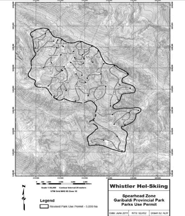
A new park use permit was issued for October 2016 through 2026. GP 2020 pointed out significant irregularities with the permit that expired in 2016 in letters to the Minister of Environment, the Honourable Mary Polak. In January, 2017, GP 2020 was informed by Ms. Jennie Aikman, Regional Director, South Coast Region, BC Parks in an information package that the permit area was reduced to exclude areas of high use in the Decker Mountain area and runs in the Iago and Quiver areas.
Inset from the park map released to GP 2020 in January 2017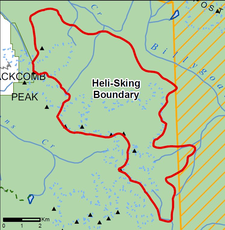
Park Use Permit 2011 through 2016
A freedom of information request filed by Garibaldi Park 2020 in January 2016 revealed the magnitude of the Park Use Permit granted to Whistler Heli Skiing Ltd. for their operations in the Spearhead Range in Garibaldi Park.
The released document reveals a much larger extant of operations than we previously believed. In fact, nearly the entirety of the Spearhead mountain range, a massive 50 square kilometers, was granted to this commercial operator. Also of note is how this area of commercial helicopter operations borders the recently deleted Spearhead Mountain Goat winter ungulate range for miles. (see Spearhead Heli-skiing Custom Map). Being that the BC Government's (and that of BC Parks) own reasearch clearly indicates that helicopter operations are one of the most disturbing human activities to mountain goats, it is not surprising that mountain goats have recently all but disappeared from their traditional ungulate range in the spearhead in Garibaldi Park.
It seems that the conflict between mountain goats and commercial interests has been abated by eliminating the animals from their traditional habitat all-together. Perhaps the recent sensitivity by BC Parks over mountain goats of late is a reflection of a guilty conscience.
Below is the black and white map of the Whistler Heli Skiing Use Permit for Garibaldi Park (Spearhead range). We have transcribe this map and overlaid it with the recently deleted spearhead mountain goat wintering range, as well as the Wilderness Conservancy Zone of the Park, which the tenure also violates (Spearhead Heli-skiing Custom Map)
The FOI
FNR-2016-61408.pdf to view (with option to download) the entire FOI / Heli Skiing Park Use Permit
What do we know from the changes to the permit area boundary?
Before we go overboard and start praising BC Parks and Whistler Heli-skiing Ltd. for addressing the significant irregulaties we noted with the previous permit let's examine the changes made for the permit expiring in 2026.
Boundary change around Decker Mountain
Decker Mountain was removed from the permit area for the benefit of Whistler Blackcomb's front country guests. Whistler Blackcomb owns Whistler Heli-skiing Ltd. The removal had nothing to do with avoiding conflict with back country skiers or protecting mountain goats from helicopter noise. A large number of Whistler Blackcomb's paying guests head into the front country around Decker to poach powder skiing lines off Decker Mountain. This is a large part of the attraction of WB's operations in that their lifts give access to large expanses of ski terrain in Garibaldi Park. So, even though it appears to be taking away heli-skiing opportunities from heli-skiing guest it is adding opportunities for WB's downhill skiing guests.
Deletion of runs in the Iago and Quiver areas
One run was deleted in Iago Glacier and one at Quiver Glacier. The Quiver deletion appears to be a shorter run of only 500 meters vertical. It might be a possibility that the run was not skied much due to the effect of global warming and reduced snow pack. There is a cliff band above the pick up landing zone that looks to be problematic in low snow. Perhaps there is insufficient snow some years to make it a viable run. We don't know. Anyway, it does not look like a significant loss of skiable terrain for the company.
Overlap with Wilderness Conservation Zone
The permit area still overlaps the Wilderness Conservation Zone, something BC Parks says it will address in a future update to the Garibaldi Park master plan. No timeline was set for it to occur. Note that in the park map released to GP 2020 in January 2017 (see Inset map above), the western boundary of the WCZ passes through Berna Lake. In the map of Garibaldi Park at the Diamond Head trail kiosk, the boundary is shown 400 meters further west. BC Parks claims the discrepancy in the boundary location is a result of less precise mapping and spatial information that was available at the time the zoning was established. We find that hard to believe. Modern map making and cartographic skills have been firmly established in Canada for well over a hundred years. The boundary of Garibaldi Park has changed repeatedly to accommodate expansion of downhill skiing into Garibaldi Park since the 1960s. Each time the boundary adjustments were shown on maps with high accuracy.
Perhaps BC Parks never adequately mapped the zoning boundaries of the park in 1990 when the park master plan was signed into effect. That is the more likely explanation. Now, only because GP 2020 pressed the issue with BC Parks, they have come clean by shifting the boundary eastward to reduce the incursion of commercial mechanized recreation into the wilderness. We can perceive it as Wilderness Conservation Zone boundary adjustment without a public involvement process. It fits in with the shenanigans we have come to expect when commercial recreation interests trump park values.
Zoning from park map at Diamond Head trail kiosk
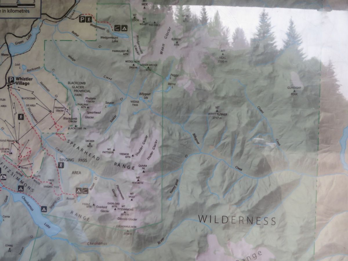
Park map showing the western boundary of the WCZ passes 400 meters west of the boundary shown on the January 2017 map in the vicinity of Berna Lake.