
- You are here:
-
Home

-
Community
-
Resources
-
Issues
-
Mainland / Southwest
-
Sunshine Coast
- Tetrahedron
Tetrahedron
Tetrahedron Provincial Park and Chapman Lake are under threat - The Forthcoming Amendment to Tetrahedron Provincial Park
The Sunshine Coast in 2015 and 2017 experienced Stage 4 drought in the Chapman system, the highest severity level of drought which bans all outdoor tap water use. The Chapman system provides water to 85% of the Sunshine Coast water users and the system refers to the watershed containing Chapman Lake and Creek. The lake and upper reaches of the creek are inside Tetrahedron Provincial Park.
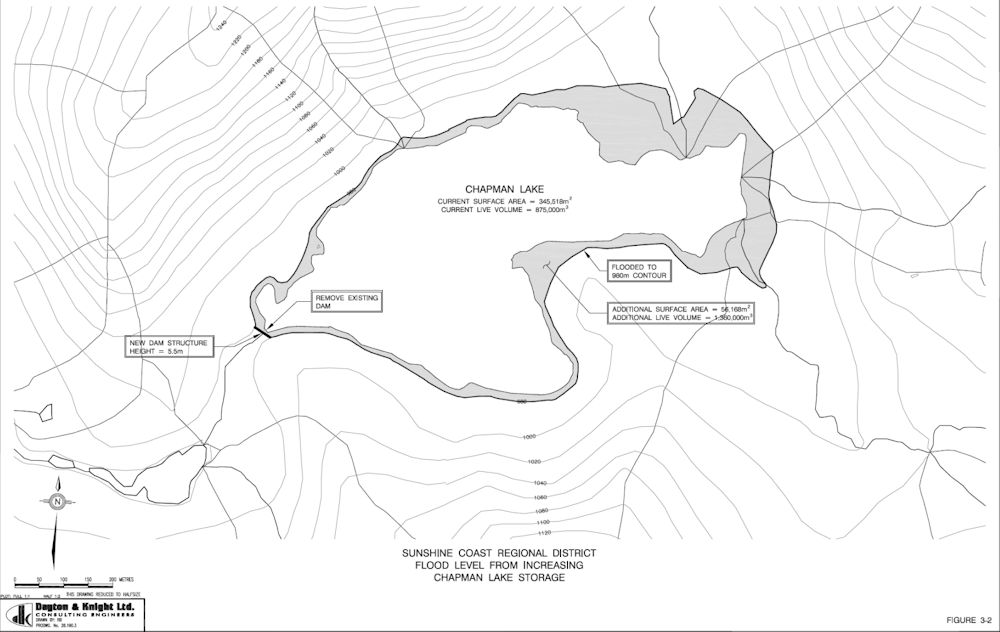
The current surface area of Chapman Lake is given as 345,518 m2 at lake full. At 8 meter drawdown, the area is reduced to be 194,445 m2. That is 56% of lake full surface area. The northeast stream is classified as high quality fish habitat suitable for all stages of fish life cycles (spawning, rearing, overwintering, migration, and spawning/holding). It contains 240 meters of good habitat that is critical in sustaining fish. During drawdown the northeast stream would flow onto dry lake bed leaving fish exposed without a channel, cover or streamside vegetation. The drying mud flats would extend 137 meters from the outflow to the lake at 8 meter drawdown. It is unlikely any fish would survive the transit and access to Dolly Varden spawning areas would not be possible.
The SCRD timetable has Chapman Lake removed from the park by a boundary amendment in fall of 2018 and construction in summer of 2019. The construction plan is to install an almost 1 meter diameter pipe at 9 meters below the lake full water level with the ability to drawdown the lake by 8 meters.
- Written by Paul Kubik
- Hits: 5527
April 28, 2018
It's no longer far-fetched to think the Tet could be roaded and logged.
The BC NDP government is proposing to declassify Tetrahedron Provincial Park to a "protected area" under the Environmental Land Use Act. As an ELUA protected area, the declassified lands would be managed for maximum beneficial land use. The designation would allow Sunshine Coast Regional District to proceed with its contentious plan to further drain Chapman and Edwards lakes. By fall 2019, a new 1-meter diameter outlet pipe will be commissioned with the ability to drawdown Chapman Lake 8 meters to 56% of its lake full surface area.
In 2007, SCRD commissioned Dayton & Knight Consulting Engineers to study increasing water storage capacity. It looked at three options:
- Raising Chapman Lake dam
- Floating pump station on Chapman Lake
- Manufactured lake at a rock quarry near Sechelt
Raising Chapman Lake dam and the floating pump station were identified as preferred options. The manufactured lake was evaluated as the most desirable option but is considered longer term as the quarry is still in operation until 2050. The option to raise the dam was saddled with two major problems. (1) It is located in a provincial park and there would be land use and permitting issues inside a provincial park. (2) The core material and concrete for the dam would need to be imported from outside the park. Without road access, material would have to be delivered by air.
The study was updated in 2013 by AECOM Canada Ltd. The commissioning of the 1-meter pipe in 2019 would make the floating pump station option redundant. Declassification of the park to a protected area would mean that a road could be built without going through a permitting process in a provincial park.
The new dam would be 4 meters higher and would flood an additional 5.6 hectares of old growth forest, which would be logged.
There you have it — road and log the Tetrahedron, no longer far-fetched.
- Written by Paul Kubik
- Hits: 7226
April 8, 2018
Water wars on the Sunshine Coast have begun. We normally think of coastal B.C. as having too much rain. Wry humour on the Sunshine Coast says that it is liquid sunshine. But climate statistics show that we have dry summers brought on by the east Pacific high pressure area which dominates in the summer months. Lack of convective rain and thunderstorms means that the west coast is much drier than the east coast of North America. Snowmelt is a major contributor to stream flow in early summer but once it's gone and without glaciers, stream flows are reduced. When drought sets in and water storage is insufficient water use must be restricted.
The Sunshine Coast in 2015 and 2017 experienced Stage 4 drought in the Chapman system, the highest severity level of drought which bans all outdoor tap water use. The Chapman system provides water to 85% of the Sunshine Coast water users and the system refers to the watershed containing Chapman Lake and Creek. The lake and upper reaches of the creek are inside Tetrahedron Provincial Park.
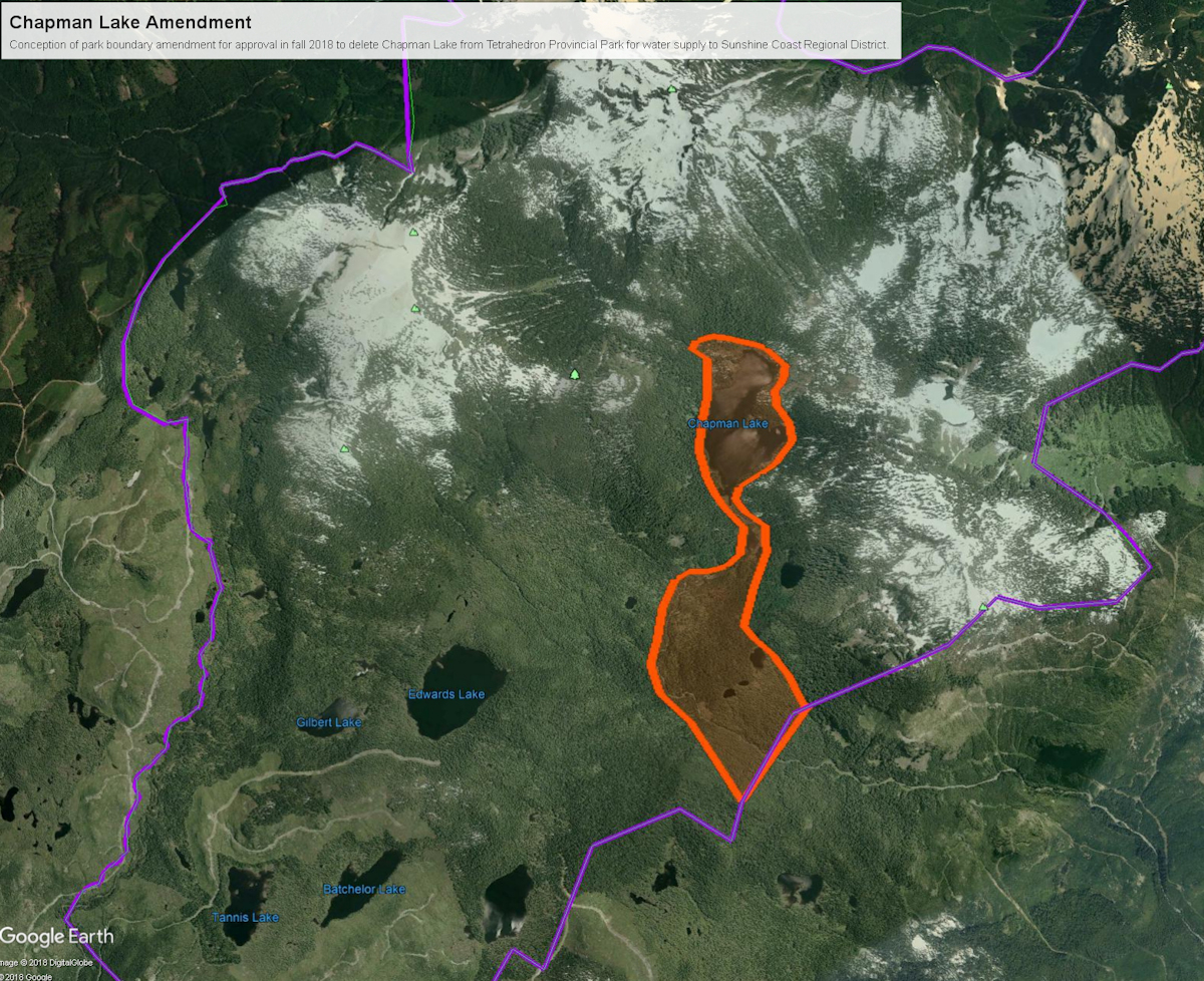
Figure 1: Conception of Chapman Lake deletion from Tetrahedron Provincial Park. Park boundary in purple, deletion in orange.
Sunshine Coast Regional District (SCRD) has set out a timetable to redraw the boundary of Tetrahedron Provincial Park to exclude Chapman Lake from the park. The lake was first tapped for water by Sechelt
First Nations, now known as shíshálh Nation. The water licence has since transferred to SCRD and the lake has an existing dam of 4 meters in height. It operates under a park use permit (PUP) originally issued when Tetrahedron Provincial Park was established in 1995. The PUP authorizes the SCRD to continue management of its existing watershed uses (Chapman/Gray Creeks) and infrastructure within the park. During drought, the water level in the lake is drawn down by up to 3 meters as permitted in the PUP.
BC Parks' mandate is to conserve land and water and provide recreation. Conservation and recreation are the twin pillars of its mission. In Tetrahedron Provincial Park, the conservation role is emphasized over recreation to ensure the highest level of water quality. Lacking from BC Parks' mandate is advocacy, which would allow the park system to respond to threats to conservation and recreation. It is the public that must ultimately advocate for the park system to counteract those threats.
The unacknowledged third pillar of BC Parks' mandate is that of permits and giveaways of land. According to the park master plan, if watershed or infrastructure improvements are proposed an impact assessment and comprehensive public consultation process must be developed. But, the Chapman Lake boundary amendment would allow SCRD to proceed with its plan to drain the lake and avoid public consultation. The amendment would only require approval from the Minister of Environment and Cabinet. It is not a given that the minister would ask for an impact assessment nor public consultation. In the past, park deletions for the benefit of commercial interests have arisen from provincial orders in council, which are directives issued on the advice of Cabinet, therefore, without debate in the legislature. For example, 33 km2 in total have been deleted from Garibaldi Park since 1966 and given to Whistler Blackcomb for ski area expansion. Some of these deletions from Garibaldi Park were authorized by orders in council without any public consultation or awareness.
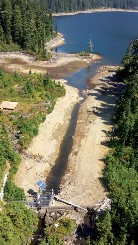
Figure 2: The original park use permit area in the foreground showing the dam, 80 meter trench and helipad. The permit area extends just past the helipad to the end of the trench where it meets the wider channel. The lake is at approximately the 3 meter drawdown level.
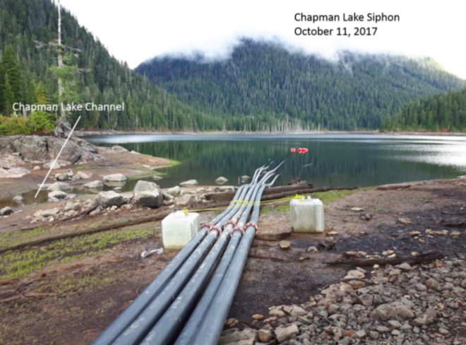
Figure 3: Temporary park use permit area approved in 2015 and extended to October 2018 showing siphon pipes installed in 2017. The temporary permit area extends a further 200 meters beyond the original permit area into deeper water. The lake is at approximately the 3 meter drawdown level.
The SCRD timetable has Chapman Lake removed from the park by a boundary amendment in fall of 2018 and construction in summer of 2019. The construction plan is to install an almost 1 meter diameter pipe at 9 meters below the lake full water level with the ability to drawdown the lake by 8 meters.
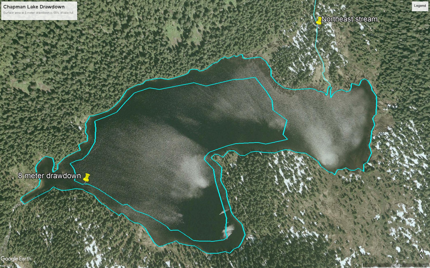
Figure 4: Chapman Lake showing the lake full outline (outer blue line) and 8 meter drawdown (inner blue line). Surface area at 8 meter drawdown is 56% of lake full. The yellow pin in upper right indicates the northeast stream.
The current surface area of Chapman Lake is given as 345,518 m2 at lake full. At 8 meter drawdown, the area is reduced to be 194,445 m2. That is 56% of lake full surface area. The northeast stream is classified as high quality fish habitat suitable for all stages of fish life cycles (spawning, rearing, overwintering, migration, and spawning/holding). It contains 240 meters of good habitat that is critical in sustaining fish. During drawdown the northeast stream would flow onto dry lake bed leaving fish exposed without a channel, cover or streamside vegetation. The drying mud flats would extend 137 meters from the outflow to the lake at 8 meter drawdown. It is unlikely any fish would survive the transit and access to Dolly Varden spawning areas would not be possible.
Available studies on the SCRD web pages did not explore the effect of 8 meter drawdown on water temperature and dissolved oxygen within the reduced lake. At lake full, there is a themocline below 4 meters where the temperature drops rapidly. Similarly, dissolved oxygen declines with depth. Water temperature at Chapman Lake rarely exceeds 20o C. Yet in the drought of 2015, surface water temperature exceeded 20o C for almost three weeks. With less volume, water temperatures would be higher. High water temperatures are known to negatively affect fish health and increase mortality. Indications are the overall effect would be highly detrimental to aquatic species.
Climate change projections are for less snowpack, drier and hotter summers. One study from 1998 suggests drawdown could extend to 16 weeks from July through October.
Sechelt mayor Bruce Milne notes there are 23,000 people on the Chapman water system and about 10,000 live in Sechelt. He says “We simply can’t afford to go through another summer like [2017], and all the climatologists are telling us to brace ourselves, this was just the beginning,” Milne added. “We can expect next summer Stage 4 at about the same time, for the same reason.”
District of Sechelt representative Doug Wright is quoted as saying, "I'm really concerned... If this doesn't get done by 2018 and we have another summer like we had..., we are going to be in real difficulty here."
The Sechelt Official Community Plan (OCP) states "Sechelt has far more residential land than is needed to meet future demands." Buildout is claimed to be 14,000 units and current build is less than 4,000 units. That leaves 10,000 units available under current zoning to be built. It lays out the welcome mat to property developers but continues on to say that one of its growth strategy principles is to protect natural habitats, ecosystems and environments.
In 2017, Coast Reporter said Sechelt municipality approved 1,600 new housing units. Where is the additional water coming from?
The SCRD meanwhile says that legislated minimum stream flow requirements meant to protect spawning salmon and riparian habitat in the lower reaches of Chapman Creek has undercut its ability to provide water such as that required for new housing developments.
SCRD population is currently growing at 0.9% per annum. That's in line with estimates from BC Stats. The 23,000 people on the Chapman system would grow to 27,500 by 2036.
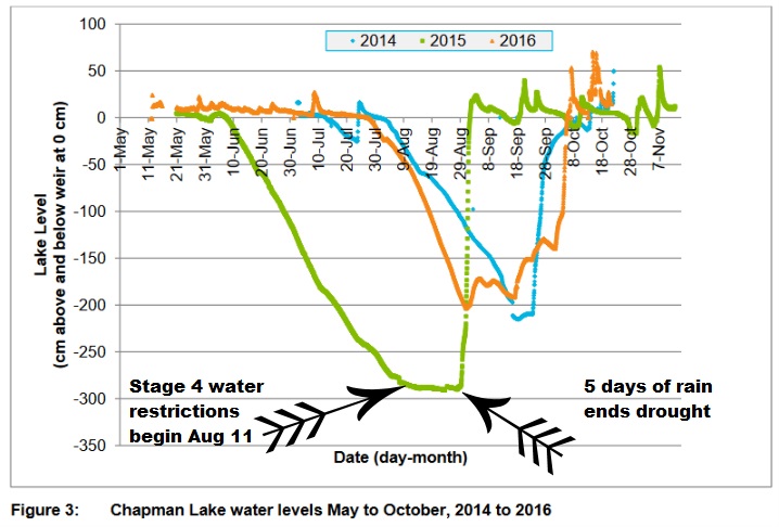
Figure 5: Chapman Lake water levels May to October, 2014 to 2016.
In 2015, drawdown from Chapman Lake began on May 30th. It was drawn down at an average rate of 3.9 cm/day until Stage 4 water restrictions were implemented on August 11th. [280 cm/72 days.] At that point, drawdown tapered off near the 3.0 meter maximum drawdown permitted under the PUP.
The SCRD foresees the Chapman system as unable to meet water demand through 2036. Their solution is not to curtail growth to what is sustainable and meets quality of life standards desired by existing residents. Their solution is to exploit natural lakes as though they are storage reservoirs with scant regard to the integrity of natural ecosystems. The park, with existing, reasonable provisions for allowing water extraction is now to be overexploited with extreme disregard for lake ecology, public perception, park integrity and aesthetic impacts. Once Chapman Lake is drained, is Edwards Lake next?
shíshálh Nation has said the additional drawdown must not be to facilitate increased growth, development and water consumption. The Sechelt OCP says its growth strategy will protect natural habitats, ecosystems and environments. Many people are not perceiving the growth strategy as sustainable. Instead, the growth strategy rewards land speculators and property developers with massive profits at the expense of the natural environment. The claims of the politicians and senior staff in the SCRD about environmental sustainability ring hollow, amounting to lip service only, nothing more than banal platitudes. What is needed are people with the courage to say no to draining Chapman Lake. Stand up to the speculator, developers and lawn waterers. A green lawn in summer is not a right, nor is it natural. Make the speculators and developers pay for water source expansion outside of the park. Let them put their money into infrastructure development before realizing their profits. Don't create a water crisis and then look for a quick solution by draining a lake.
- Written by Paul Kubik
- Hits: 5415
For Sunshine Coast Regional District, it is full steam ahead for deleting Chapman Lake from Tetrahedron Provincial Park. Their timeline for it to occur is the fall of 2018, about 6 months from now. I asked Jennie Aikman, South Coast Regional Director of BC Parks, for a map of the park amendment. She said she didn't have anything to share publicly until uncertainty in her office regarding the project is resolved. Considering that the issue has been on the radar for BC Parks since at least 2016 that is surprising. Meanwhile, the window for public consultation narrows with the likelihood of any meaningful participation decreasing as the SCRD continues to force the issue by brinkmanship.
Backcountry Access BC took to the drafting table to come up with a map for conceptual purposes that shows the extent of the contemplated boundary adjustment. It would hollow out the park, sever access to McNair cabin and Panther Peak.

- Written by Paul Kubik
- Hits: 6337
Updated: April 4, 2018
The timeline below is showing troubling lack of oversight from some of our government agencies.
2010: Sechelt Official Community Plan states "Sechelt has far more residential land than is needed to meet future demands." Buildout is claimed to be 14,000 units and current build is less than 4,000 units. That leaves 10,000 units available under current zoning to be built. It continues to say that one of its growth strategy principles is to protect natural habitats, ecosystems and environments. But wait, where is the water coming from? The answer is from the already maxed out Chapman Lake watershed. How is that protection of natural habitat, ecosystems and environments?
June 2013: Sunshine Coast Regional District adopts the Comprehensive Regional Water Plan (CRWP). Chapman Lake is one part of the plan and supplies water to 85% of Sunshine Coast Regional District (SCRD) water users.
2015: FSCI Biological Consultants (FSCI) determined that a flow of 200 liters/second is required for spawning salmon and to meet Environmental Flow Needs (EFN) in Chapman Creek. The EFN is required under the B.C. Water Sustainability Act. The SCRD blames the EFN for furthering the deficit of water storage that was identified in the CRWP. It claims that the EFN results in 20 to 30 days per annum that water is not available for SCRD water users.
Summer 2015: Bad drought. Chapman Lake expansion project is fast-tracked by Sunshine Coast Regional District.
2016: Consultants AECOM propose constructing a deeper water intake at Chapman Lake, raising the dam, adding a diesel or propane pump station and drawing down the lake by 8 meters. Construction was scheduled but never started. The project would increase drawdown of Chapman Lake from its current 3 meters to 8 meters of the 30 meter deep Chapman Lake. It would double the accessible water for extraction to benefit SCRD water users.
2016: Environmental assessment report from AECOM quotes shíshálh Nation that the additional drawdown should not be used to prevent Stage 4 drought restrictions. The additional drawdown must not be to facilitate increased growth, development and water consumption.
March 6, 2017: BC Parks informs SCRD that a boundary change or reclassification of Tetrahedron Provincial Park is needed before a park use permit is granted to construct a deeper channel to draw more water from Chapman Lake. Ministry of Forests and Natural Resource Operations (FLNRO) evaluates a new water licence application. As part of the water licence application, the SCRD reported Chapman Creek had insufficient flow for fish below the treatment plant 14% of the time in 2015 and 2% of the time in 2016. SCRD procedure is to permit only 77% of water flow required for fish habitat and water quality as stipulated by Department of Fisheries and Oceans during the summer dry period.
April 26, 2017: District of Sechelt representative Doug Wright is quoted as saying, "I'm really concerned... If [the Chapman Lake expansion project] doesn't get done by 2018 and we have another summer like we had two years ago, we are going to be in real difficulty here."
April 28, 2107: Sechelt municipality approves 1,600 new housing units according to Coast Reporter.
June 8, 2017: Lack of affordable housing reaches crisis levels according to Coast Reporter. Perhaps mega-homes are being approved and overbuilt leading to the affordability crisis.
Summer 2017: Another bad drought. Three siphon pipes are installed at Chapman Lake by SCRD. Was a park use permit or authorization issued for the work?
March 1, 2018: Janette Loveys, chief administration officer for the SCRD, releases a staff report that says, in part, that drawing down Chapman Lake by 8 meters is tapped as the most feasible and cost effective water source that can be exploited in the area. It also says it has the least environmental impact compared to other water sources and lakes. Ms. Loveys estimates the park boundary adjustment to remove Chapman Lake from Tetrahedron Provincial Park will be completed in fall of 2018 with the assistance of BC Parks. No word on planning for public participation in reaching the decision is announced. She further forecasts that BC Parks will issue a separate park use permit in spring of 2019 and that Ministry of Forests, Lands, Natural Resource Operations and Rural Development (FLNRORD) will issue a water license.
Source: Sechelt Official Community Plan 2010
Source: SCRD Comprehensive Regional Water Plan
Source: http://www.thelocalweekly.ca/chapman-lake-pipeline-project-delayed-again/
Source: Sunshine Coast Regional District staff report, March 1, 2018
- Written by Paul Kubik
- Hits: 4621
Click on the link to view the document: Chapman Lake water works: Tetrahedron Outdoor Club letter to BC Parks (2016-03-15)