
- You are here:
-
Home

-
Community
-
Resources
-
Issues
-
Mainland / Southwest
-
Sunshine Coast
- Tetrahedron
Tetrahedron
Tetrahedron Provincial Park and Chapman Lake are under threat - The Forthcoming Amendment to Tetrahedron Provincial Park
The Sunshine Coast in 2015 and 2017 experienced Stage 4 drought in the Chapman system, the highest severity level of drought which bans all outdoor tap water use. The Chapman system provides water to 85% of the Sunshine Coast water users and the system refers to the watershed containing Chapman Lake and Creek. The lake and upper reaches of the creek are inside Tetrahedron Provincial Park.
The current surface area of Chapman Lake is given as 345,518 m2 at lake full. At 8 meter drawdown, the area is reduced to be 194,445 m2. That is 56% of lake full surface area. The northeast stream is classified as high quality fish habitat suitable for all stages of fish life cycles (spawning, rearing, overwintering, migration, and spawning/holding). It contains 240 meters of good habitat that is critical in sustaining fish. During drawdown the northeast stream would flow onto dry lake bed leaving fish exposed without a channel, cover or streamside vegetation. The drying mud flats would extend 137 meters from the outflow to the lake at 8 meter drawdown. It is unlikely any fish would survive the transit and access to Dolly Varden spawning areas would not be possible.
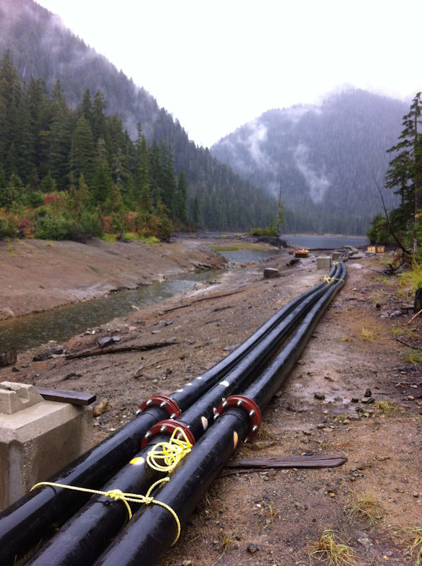
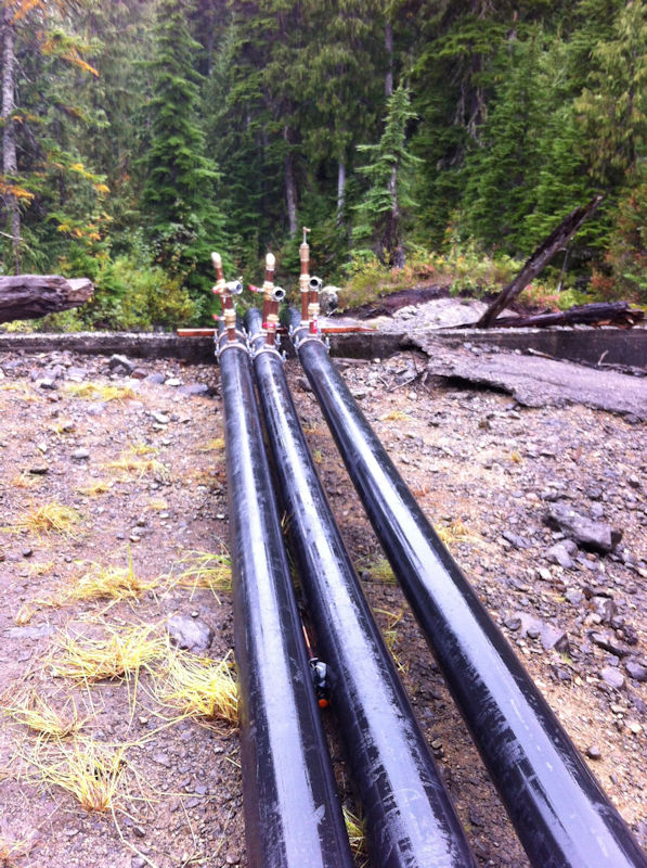
The SCRD timetable has Chapman Lake removed from the park by a boundary amendment in fall of 2018 and construction in summer of 2019. The construction plan is to install an almost 1 meter diameter pipe at 9 meters below the lake full water level with the ability to drawdown the lake by 8 meters.
- Written by Paul Kubik
- Hits: 4667
Chapman Lake siphon pipes installed summer 2107. Photo date: September 30th, 2017. backcountryBC is still trying to find out if a park use permit and water license were issued prior to development.
The photos appear to show the lake at the 3 meter drawdown level. SCRD is proposing to draw down the lake a further 5 meters. Or perhaps raise the dam and flood 5 meters of old growth higher.
- Written by Paul Kubik
- Hits: 4744
The Chapman watershed provides of 90% of the water supply within the Sunshine Coast regional district's water service area. The SCRD projects up to 2% population growth rate to 2036. The SCRD advocates for "intensive demand management", i.e. curtailing water use. Even with IDM, by 2036, the SCRD theorizes that it's goal of having adequate water storage capacity for a 1 in 25 year drought return scenario will not be met. It projects only having sufficient water capacity for 14 out of every 15 years. Without curtailment of demand, the regional district foresees only having adequate supply every 10 out of 11 years. What it means is that water demand if forecast to exceed supply during drought conditions every 25, 15 or 11 years under the indicated scenarios.
The SCRD is proposing to drain Chapman Lake during droughts by drawing it down as much as 8 meters. The depth of the lake at its deepest is about 32 meters so the draw down would represent well over 25% of the lake's volume due to it V-shaped basin.
Chapman Lake is inside Tetrahedron Provincial Park so the draw down would represent a significant change to the park's ecosystem and integrity.
One storage option is to engineer a lake at a gravel quarry well outside Tetrahedron Provincial Park. However, the gravel pit is still in operation and expected to continue until 2050.
Two options directly affect Chapman Lake.
- Draw down the lake using a floating pump. The diesel-powered pumps would operate 16 weeks and drawdown the lake 6.5 meters during a 1 in 20 year drought.
- Raise the lake by raising the existing dam from the existing 1.5 meters to 4 meters in height. It would flood an additional 5.6 hectares of land.
A consulting company rated the ecological disturbance of raising the lake as Very High and of the floating pump as Moderate-High. The deleterious effect of increased flooding is rated as Very High. The effect on the park and recreation is rated as Very High and High in order of the two options numbered above.