
- You are here:
-
Home

-
Community
-
Resources
-
Issues
-
Mainland / Southwest
-
Sea to Sky
- Non motorized zones
Non motorized zones
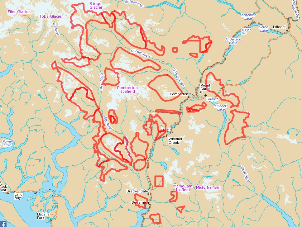
The Sea to Sky Land and Resource Management Plan was adopted in 2008 and specifies a number of non motorized zones that fall under the jurisdiction of the Ministry of Forestry, Lands, and Natural Resource Operations (MFLNRO). The following map specifies the detailed boundaries of these zones.
At the present time most of them have not been implemented with a Section 58 order and therefore not enforcable by the Conservation Office. Negotiations are beginning to get more Section 58s put in place on these zones.
For Gmap Click Here.
Issue Lead Advocate - Bill Maurer
The LRMP identifies the following non-motorized zones:
- Ashlu
- Birkenhead
- Blanca Lakes core
- Cloudburst
- Echo Lake
- Elaho
- Gravell Creek
- Joffre Creek
- Lizzie Creek
- Lower Soo
- Mamquam
- Miller Creek
- Mount Currie
- North Creek
- North Hibachi Ridge
- Phelix Creek west
- Rainbow
- Salal Creek
- Sims
- Sky Pilot
- South Creek
- Sockeye Creek
- Squamish River
- Watersprite
- Written by Bill Maurer
- Hits: 6330
The Sea to Sky Land and Resource Management Plan was adopted in 2008 and specifies a number of non motorized zones that fall under the jurisdiction of the Ministry of Forestry, Lands, and Natural Resource Operations (MFLNRO). The following map specifies the detailed boundaries of these zones.
At the present time most of them have not been implemented with a Section 58 order and therefore not enforcable. Negotiations are beginning to get more Section 58s put in place on these zones.
Click the button at the bottom of the map to download a gpx file compatible with your device. The tracks within the file contain the names of the zone they surround.
- Min Elevation
- 0 m
- Total Distance
- 1319.59 km
- Max Elevation
- 0 m
- Way Points
- 0
- Total Elevation Gain
- 0 m
- Track Points
- 29589
- Total Elevation Loss
- 0 m
| Values not available in the file may shown as 0. | |||
|
This track was downloaded 13 time(s). Please register/login to download this track. |
- Written by Bill Maurer
- Hits: 7157
This map contains the areas which have legal non-motorized status. It covers the full Sea to Sky corridor from the North Shore to Lillooet and west as far as the Strait of Georgia. If you spot snowmobiles or ATVs in any of these zones please report them to the Conservation Office. They have a 24 x 7 RAPP line which can be reached at 1-877-952-7277 (RAPP) or #7277 from a cell phone. They will take a report and may dispatch someone if they are in the area.
At the present time, the vast majority of these zones are provincial parks but the LRMP Non motorized zones identifies a number of additional zones for legal designation as non-motorized. This map will be updated as these zones are given their deserved legal (section 58) status. It has been almost 10 years since the master plan was adopted and to date only one area in the Callaghan Valley has been given full status.
For Gmap Click Here. Click the button at the bottom of the map to download a gpx file compatible with your device. The tracks within the file contain the names of the zone they surround. Neighbouring boundaries have been removed in situations where multiple zones sit adjacent to each other. This is the case with Garibaldi Park, Pinecone Burke Park, and Golden Ears Park which combined extend all the way from Whistler to the Lower Mainland, While most of the zones are provincial parks, there is also an area in the Callaghan Valley surrounding Callaghan Park which has been given full legal (section 58) status.
- Min Elevation
- 1 m
- Total Distance
- 1512.57 km
- Max Elevation
- 2777 m
- Way Points
- 1
- Total Elevation Gain
- 53919 m
- Track Points
- 20692
- Total Elevation Loss
- 53584 m
Waypoint/Placemark Details
| # | Elevation | Distance | |
|---|---|---|---|
|
1006 m height
|
|||
| 1 |
|
1006 m | 0 km |
| Values not available in the file may shown as 0. | |||
|
This track was downloaded 0 time(s). Please register/login to download this track. |