
This is an older article written in 2013 by Leigh McClurg at http://pebbleshoo.com/athelney-pass-the-park-that-never-was/
I wanted a record of it here so McClurg's article it is not forgotten or lost on the internet:
-x-
I uttered those words as myself and Spring had just found a large rock that would be comfortable to sit on as we unpacked our lunches. We where sitting atop “The Elephant”, an unofficially named volcanic plug of rotten rock. A few kilometers away we could just about hear the whoops! of elation as 4 of our friends were reaching the summit of Ochre Mountain. We shouted out to them, not sure if they could hear us, and settled in to spend a few minutes soaking in the views before heading on to our next peak of the day. “Athelney Pass” I said to myself “… what a place!”
The previous day myself, Spring and 5 other friends had spent 8 hours with heavy packs on our backs hauling our camping gear 15km’s up Salal Creek. For the most part you can walk on river rocks to follow the course of the creek, at other times you need to deke into the forest to avoid where the creek abuts the shore. It had been a hard approach hike. On paper it looks relatively easy by our standards with only 800m’s of elevation being gained over those 15km’s. We’d previously camped on Panorama Ridge in Garibaldi Provincial Park which was a 15km hike one way but with double that elevation gain and we had found that to be a breeze. This approach hike was a different kind of hard though. It was mentally fatiguing. On most trails we can just turn our brains to autopilot, but for walking on these polished river rocks we had to always be vigilant in our foot placements. Stepping on the wrong rock could mean a rolled ankle or worse. We could never really let our minds rest, we had to always be paying attention about our next foot placements.
We eventually reached our campsite, beside a dilapidated mining cabin, and pitched our tents. The valley had lost the sun by the time we finally arrived and the mosquitoes had come out in their droves to feed. Nevertheless, we couldn’t help but feel like we’d arrived somewhere special. We looked out towards the large Ethelweard Glacier across from us, and turned in for the night.
The next morning a few different objectives for the day were discussed. Myself and Springs plans didn’t really match up with anyone elses so just the two of us set out together. Everyone had decided to stay on the West side of Athelney Pass. The peaks on the East side of the Pass look considerably more intense and would likely require glacier travel gear. To keep weight down and avoid needing to carry harnesses, ropes, crampons, ice axes… etc for this trip we’d explore only the peaks to the West. There are glaciers to the West also but they can be avoided to visit some of the peaks.
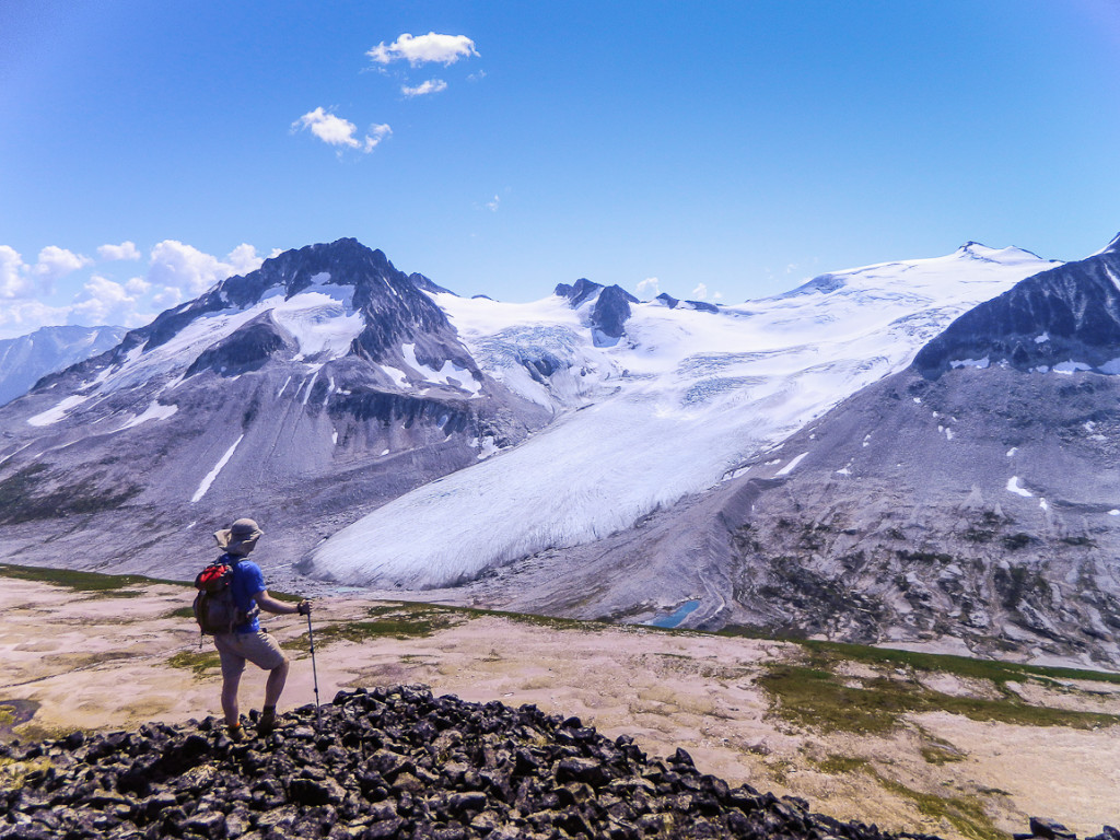
We headed out and hiked up the steep west side of the Pass and topped out on a plateau. This plateau felt very unique compared to anywhere else we’d visited in the Coast Mountains. It’s made up of sand like pumice mixed with rocks of nearly every color of the rainbow. Between all this are rivulets, streams, creeks and tarns all over the plateau and surrounding them are mosses and alpine flowers. We passed through them and headed west towards a purple and redish colored bump. Our objective for the day was to see if we could easily get to the summit of Red Sail Peak, some 6km’s one way from our camp. I’d evaluated the route in Google Earth and it looked straightforward, but knew that micro-terrain between grid-lines on topo maps can put the kibosh on even the best laid plans.
Shortly after passing the purple/red bump we came upon a large cairn, the kind people build on summits. I thought it was an odd place for it until I went to move past it. The ridge quickly degraded in rock quality, becoming loose and unstable and narrowing considerably. Myself and Spring evaluated our options. We didn’t have helmets with us and we could not see the rest of the ridge from our vantage point. We could also now better see the summit of Red Sail. It was at least a loose class 3 scramble, at most low class 5 on rotten rock. It looked time consuming and not what we had planned for.
We decided this wasn’t the day for it. I guess whomever built that large cairn felt the same way also as it appeared they had made this point in the ridge their own personal summit. This vantage point proved useful in one way at least, it provided us the ability to see an easier and quicker way of accessing Red Sail Peak, when we return to it at a future date.
We reworked our day now that we’d seen the area, we’d traverse back along the ridge we were on and summit The Elephant which lay at the Eastern end of it and then hike to the summit of Salal Peak to the North and then, if we had time, hike across to Ochre Mountain.
At the Elephant we had lunch and seen that our friends had made the summit of Ochre. We continued on to Salal Peak, passed some pretty fresh Cougar tracks and ascended a snow slope to reach the easily gained summit of Salal. From here we could see down Salal Creek, our approach from the previous day and across to some immense glaciers that feed it with melt water. We could see immediately to the North a subsummit of Salal that appeared to offer a better vantage point of these glaciers, so we headed towards it and reached it easily some 20 minutes later. From here Spring decided to take a break, but I wanted a better look at the glaciers from further down so I kept on moving.
It’s hard to describe the feeling of being in this place. A recurring topic throughout the day had been why such an amazing place had not been protected as a park. As I progressed towards the edge of the slope to get a better view of the glaciers across the valley from me I passed pallets of rusting mining equipment and the makings of another cabin left to rot and blow around the slope as garbage. I haven’t before felt the urge for a place to be protected. Part and parcel with being in the mountains is knowing that I share my recreation here with those who make their livings here, whether it be mining or forestry… etc. I need to use mining and forestry roads to access these places. When I’m on a summit and I see the cut blocks made by the forestry industry or open-pit mines I find them ugly but I accept them.
Not here though. The feeling I get in Athelney Pass is no different to the feeling I’ve gotten in Garibaldi Park or any of the amazing National Parks of Canada. When you stand on Panorama Ridge you understand why Garibaldi Park was protected. It’s not like everywhere else. There is a uniqueness to it that needs to be experienced first hand by going there. There was a disgust in me at seeing the carelessly abandoned mining equipment. In front of me was this brightly ochre colored slope that plummeted down towards Salal Creek, I had noted it from below as I had hiked in. To my left was the tongues of three immense glaciers, the clear remnants of some gargantuan neve glacier that snaked it’s way down Salal Creek in the past. To my right was spires of volcanic rock jutting out of the pumice slope. I could feel the katabatic winds cool against my skin and could see many of the peaks that surround the huge Bridge Glacier in the distance. But, when I turned my back to this, behind me was rusting oil drums, bed springs, steel cables, rotting floorboards of a cabin that was never built among a large, wind strewn pile of other garbage. How was this allowed to just be put here?
I left those thoughts behind and hiked back to meet Spring. The day was far from over yet. As we reversed our route to Salal Peak we talked about descending back to camp now and leaving Ochre Mountain for possibly the next morning or another trip. As we started to descend off Salal in the general direction of our camp we made our minds up. We’d continue on to Ochre Mountain. We reasoned that the Pass below was losing Sunlight now and the mosquitoes were starting to come out stronger, whereas up here on the peaks, aside from the odd horsefly, we’d been left alone by the bugs and we still had the sun for at least another few hours. Plus the weather had been perfect all day. Warm, with some odd respites from the heat with some cloud cover and a cool breeze blowing in intermittently, it would be a shame to cut such a perfect day in such an amazing place short.

As we descended off Salal Peak, we took what appeared to be a snowfield down to a tarn. We stayed close to the edge but not too close in case there was a randkluft undercutting the snow. It felt safe, we where likely only 15ft from the edge. Suddenly I plunged in to the snow and spread out my arms to halt my descent. I looked down expecting to see rock. I imagined a snow bridge between some boulders had given out. What I saw shocked me, an open crevasse, with my feet dangling in space and a bottom that was far enough away that light wasn’t reaching it. I quickly pushed my way out, hoping the lips of this gaping maw would hold and rolled off to the side.
Before planning this trip I’d read every report online for this area, including Salal Peak. Everyone takes this snow slope up and nobody ropes up. I evaluated it myself and could see no reason to rope up as it looked like a snow field left over from the previous winter, not an old, crevassed, glacier. I, and it appears everyone else I’ve read about, was wrong. It’s a glacier and the crevasses extend almost all the way up to the rock sides in places.
A little shaken, I quickly descended back to the rock below. Here, at a meltwater tarn, we had a quick nap on a large flat rock. It had already been a 9 hour hiking day and we’d put on quite a few kilometers, we still had another 3 hours or more to go to summit Ochre and get back to camp.
Shortly after our nap we headed towards Ochre by ascending up and over the shoulder of The Elephant. We progressed towards the West ridge of Ochre but upon reaching it we realized the rock quality wasn’t as good as we had imagined. We could see a number of gendarmes along this ridge that might also slow our progress. If we’d had time we would have tackled it but we didn’t so we dropped down to the south east and traversed below the ridge crest until shortly before the summit were we reascended the ridge. We made the summit easily from there and once again took in the expansive views all around us. We could now see a lot further down the Pass towards the 41 person strong community of Gold Bridge, and we had a good vantage point on the Ethelweard Glacier and it’s distinctive tongue of crevassed ice.
The winds started picking up now and the day had the distinctive feel of starting to turn to night. We headed back down quickly and crossed over the sand flats of the plateau. We met up with some bear tracks in the sand that were heading in our intended direction so we started hooting and hollering to try and scare it off before we ran into it. We decided to cut down into the Pass earlier than we had come up so that we would meet up with our camp in a more direct line. This was a gamble as the sides of the Pass are pretty steep but we knew we’d have gravity on our side at least. We followed a dry rivulet down which eventually started to seep water and eventually it became a small creek, so we traversed into the dense trees next to the creek to continue down. These trees were incredible dense. So dense that most of the time we weren’t even touching the ground, just walking on the branches. After 15 minutes of this we pushed out into the Pass and made our way back to camp. It had been a good day and it felt like we’d sucked all the marrow out of it that we could.
That night we ate well, we hadn’t scrimped on food for this trip and had luxuries like cheese, sausages and beer. When the light faded sufficiently we watched the Milky Way arching above us for a good while and collectively felt small, very very small.
We turned in late that night and awoke early. Some in our group, who imagined they’d be moving slower than some of us, left early. The rest of us had breakfast and got packed and moving quickly around 8am, spurred on by the ever increasing density of mosquitoes around us. The hike out went quickly for me, although I was glad to leave those river rocks behind once and for all. At our vehicles the bugs once again amassed around us and we quickly loaded into our respective 4×4’s. We barrelled down deteriorating roads, to gravel roads, to empty paved roads and eventually back to civilization and the highway.
It’s always a shock coming out of the wilderness and back into busy towns and cities. As we refueled at a gas station I could see the bins overflowing with garbage from the days traffic. I thought about the various piles of garbage that had been left in Athelney Pass by past mining interests. Humans, myself included, create a lot of garbage for this world, it’s an inconvenient truth, but I still can’t shake the feeling that Athelney Pass should be protected from it.
Over that weekend, apart from those in our group, nobody else set foot in Athelney Pass. This was the long BC Day Weekend, when every known campsite was likely at capacity and when the Provincial and National Parks were likely bursting at the seems with day hikers and backpackers, yet, in this jewel of the Coast Mountains, we were alone. It would be easy for me to keep shtum about this place and try to keep it for myself and those who already know about its beauty, but I don’t believe that’s how a place like this will ever get protected. Miners already know about it and have been persistently in the area, as recently as 2008, looking for molybdenum ore. How a place like this gets protected is through persistent interest from recreationalists in my opinion. So look at your calender, book a date, and visit Athelney Pass for yourself. My pictures don’t even scratch the surface of how amazing this place is, you need to see it for yourself.
So? Do!