
- You are here:
-
Home

-
Maps and Media
-
Maps and Mapping Data Repository
- Wildlife Maps
Wildlife Maps
GAS Overview Map with Wildlife Areas
- Written by Chris Ludwig
- Hits: 3726
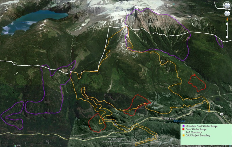
The following is a detailed Overview Map of the Garibaldi at Squamish Ski Proposal (GAS) that includes the critical wildlife habitat that it is direct conflict with. Without drastic change to the proposal, the Deer and Mountain Goats will be displaced, and may likely die. Source: The website for the Garibaldi at Squamish Proposal.
Garibaldi at Squamish Boundary Map to view high resolution image
Garibaldi At Squamish project boundary:
Click Here for Gmap Rendering
- Min Elevation
- 0 m
- Total Distance
- 53.25 km
- Max Elevation
- 0 m
- Way Points
- 0
- Total Elevation Gain
- 0 m
- Track Points
- 0
- Total Elevation Loss
- 0 m
| Values not available in the file may shown as 0. | |||
|
This track was downloaded 1 time(s). Please register/login to download this track. |
Mountain Goat Winter Range Spearhead
- Written by Paul Kubik
- Hits: 3340
The map below shows mountain goat winter range in Garibaldi Park.
Click Here for Gmap Rendering (use this option if map below fails to display)
The ARC-INFO SHAPE files were obtained from BC Parks.
- Min Elevation
- 0 m
- Total Distance
- 146.22 km
- Max Elevation
- 0 m
- Way Points
- 0
- Total Elevation Gain
- 0 m
- Track Points
- 850
- Total Elevation Loss
- 0 m
| Values not available in the file may shown as 0. | |||
|
This track was downloaded 0 time(s). Please register/login to download this track. |
Deer and Moose Winter Range U2-002
- Written by Paul Kubik
- Hits: 4070
The BC government publishes the boundaries of approved deer and moose winter range as part of the Forest and Range Practices Act.
Garibaldi At Squamish will be destroying one square kilometer of critical deer winter range. No compensatory habitat can be added since winter range requires low elevation old growth, which can take 350 years to establish. For all intents and purposes, the critical habitat is lost forever. GAS gets the deer winter range for about $5,000 per acre according to the rates established by the Mountain Resort Branch. So the market value of the deer winter range is set at $1.2 million.
Click Here for Gmap Rendering
- Min Elevation
- 0 m
- Total Distance
- 4.05 km
- Max Elevation
- 0 m
- Way Points
- 0
- Total Elevation Gain
- 0 m
- Track Points
- 0
- Total Elevation Loss
- 0 m
| Values not available in the file may shown as 0. | |||
|
This track was downloaded 1 time(s). Please register/login to download this track. |
The map above shows approved deer and moose winter range in surrounding the Sea to Sky Highway. Approved means as set out in the Order - Ungulate Winter Range #U2-002.
The GPX were generated from ARC INFO shape files at 200 meter spacing.
Ungulate winter range shape files were downloaded from:
http://www.env.gov.bc.ca/wld/frpa/uwr/approved_uwr.html
Mountain Goat Winter Range U2-002 Squamish
- Written by Paul Kubik
- Hits: 4640
The BC government publishes the boundaries of approved mountain goat winter range as part of the Forest and Range Practices Act.
The map below shows approved mountain goat winter range in Garibaldi Park and surroundings bounded by Sea to Sky Highway. Approved means as set out in the Order - Ungulate Winter Range #U2-002.
The GPX were generated from ARC INFO shape files at 100 meter spacing.
Click Here for Gmap Rendering (use this option if map below fails to display)
- Min Elevation
- 0 m
- Total Distance
- 5.67 km
- Max Elevation
- 0 m
- Way Points
- 0
- Total Elevation Gain
- 0 m
- Track Points
- 0
- Total Elevation Loss
- 0 m
| Values not available in the file may shown as 0. | |||
|
This track was downloaded 0 time(s). Please register/login to download this track. |
Ungulate winter range shape files were downloaded from:
http://www.env.gov.bc.ca/wld/frpa/uwr/approved_uwr.html
The 58 areas south and east of Highway 99 that comprise all of Garibaldi Park, Howe Sound East, Indian River, northern parts of Pinecone-Burke Provincial Park and Golden Ears Provincial Park were selected for this GPX file. A notable absence is the Spearhead mountain goat winter range. It was not published by FLNRO.
According to the PDF file accompanying the boundary shape file:
The following practices are established as management objectives inside the ungulate winter range:
Maintain mountain goat winter ranges to provide high suitability habitat. Habitat attributes include snow interception, foraging opportunities, escape terrain, steep south and west-facing windswept ridges/slopes, conifer bluffs, shrub/grass communities, and security cover.
From a recreation point of view the most germane point is that trail construction is not permitted in approved goat winter range.