
- You are here:
-
Home

-
Maps and Media
-
Maps and Mapping Data Repository
- Other Boundary
Other Boundary
Brohm OGMA-Legal
- Written by Paul Kubik
- Hits: 6281
Old growth management areas in and around Brohm Ridge that are classified by B.C. as "legal".
Click Here for Gmap Rendering
- Min Elevation
- 0 m
- Total Distance
- 390.48 km
- Max Elevation
- 0 m
- Way Points
- 0
- Total Elevation Gain
- 0 m
- Track Points
- 13543
- Total Elevation Loss
- 0 m
| Values not available in the file may shown as 0. | |||
|
This track was downloaded 2 time(s). Please register/login to download this track. |
Garibaldi OGMA-Legal
- Written by Paul Kubik
- Hits: 4908
Old growth management areas in and around Garibaldi Park that are classified by B.C. as "legal".
Click Here for Gmap Rendering
- Min Elevation
- 0 m
- Total Distance
- 390.48 km
- Max Elevation
- 0 m
- Way Points
- 0
- Total Elevation Gain
- 0 m
- Track Points
- 13543
- Total Elevation Loss
- 0 m
| Values not available in the file may shown as 0. | |||
|
This track was downloaded 0 time(s). Please register/login to download this track. |
GAS Project Boundary
- Written by Paul Kubik
- Hits: 6726
Garibaldi At Squamish project boundary.
Click Here for Gmap Rendering
- Min Elevation
- 0 m
- Total Distance
- 53.25 km
- Max Elevation
- 0 m
- Way Points
- 0
- Total Elevation Gain
- 0 m
- Track Points
- 0
- Total Elevation Loss
- 0 m
| Values not available in the file may shown as 0. | |||
|
This track was downloaded 1 time(s). Please register/login to download this track. |
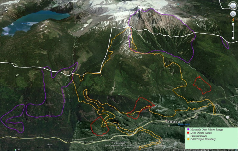
The following is a detailed Overview Map of the Garibaldi at Squamish Ski Proposal (GAS) that includes the critical wildlife habitat that it is in direct conflict with. Without drastic change to the proposal, the Deer and Mountain Goats will be displaced, and may likely die. Source: The website for the Gariabldi at Squamish Proposal.
Click Here to view high resolution image
Pinecone Lake RA1 non-motorized boundary
- Written by Paul Kubik
- Hits: 7453
Pinecone Lake RA1 zoning - non-motorized boundary.
Click Here for Gmap Rendering
- Min Elevation
- 0 m
- Total Distance
- 13.65 km
- Max Elevation
- 0 m
- Way Points
- 0
- Total Elevation Gain
- 0 m
- Track Points
- 0
- Total Elevation Loss
- 0 m
| Values not available in the file may shown as 0. | |||
|
This track was downloaded 1 time(s). Please register/login to download this track. |
Skookum RA1 non-motorized boundary
- Written by Paul Kubik
- Hits: 4181
Skookum RA1 zoning - non-motorized boundary.
Click Here for Gmap Rendering
- Min Elevation
- 0 m
- Total Distance
- 22.02 km
- Max Elevation
- 0 m
- Way Points
- 0
- Total Elevation Gain
- 0 m
- Track Points
- 28
- Total Elevation Loss
- 0 m
| Values not available in the file may shown as 0. | |||
|
This track was downloaded 3 time(s). Please register/login to download this track. |