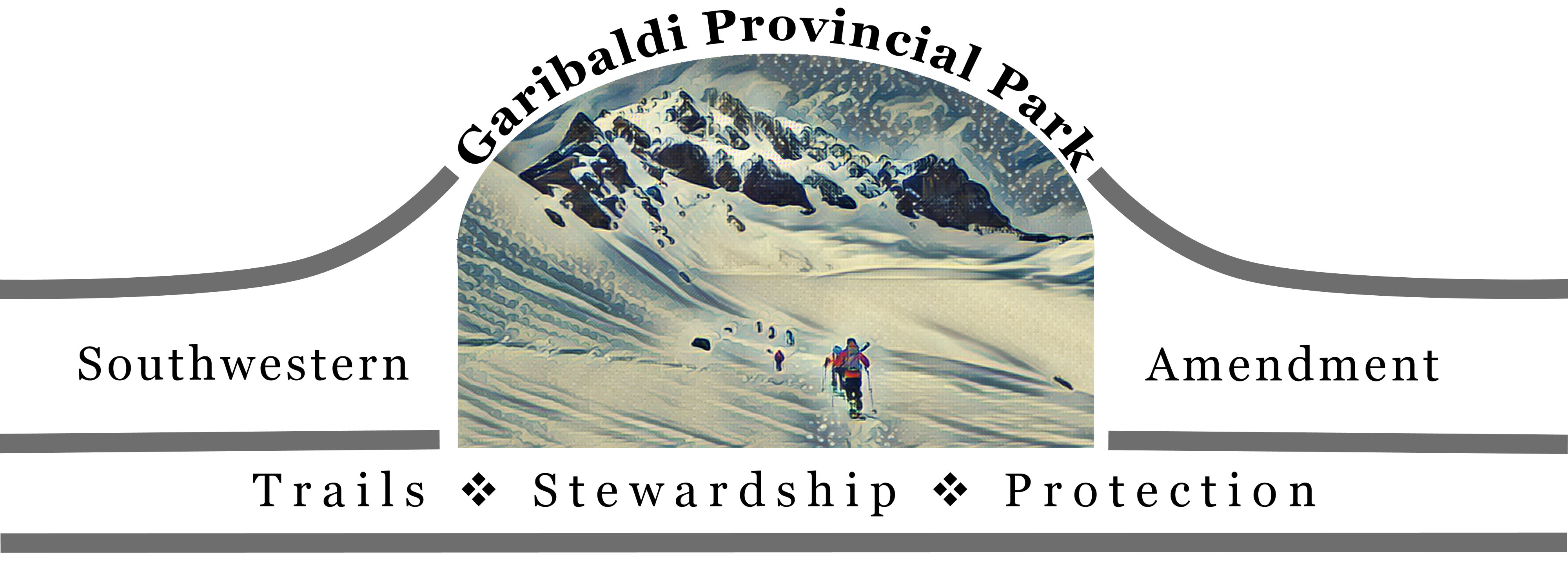
Introduction
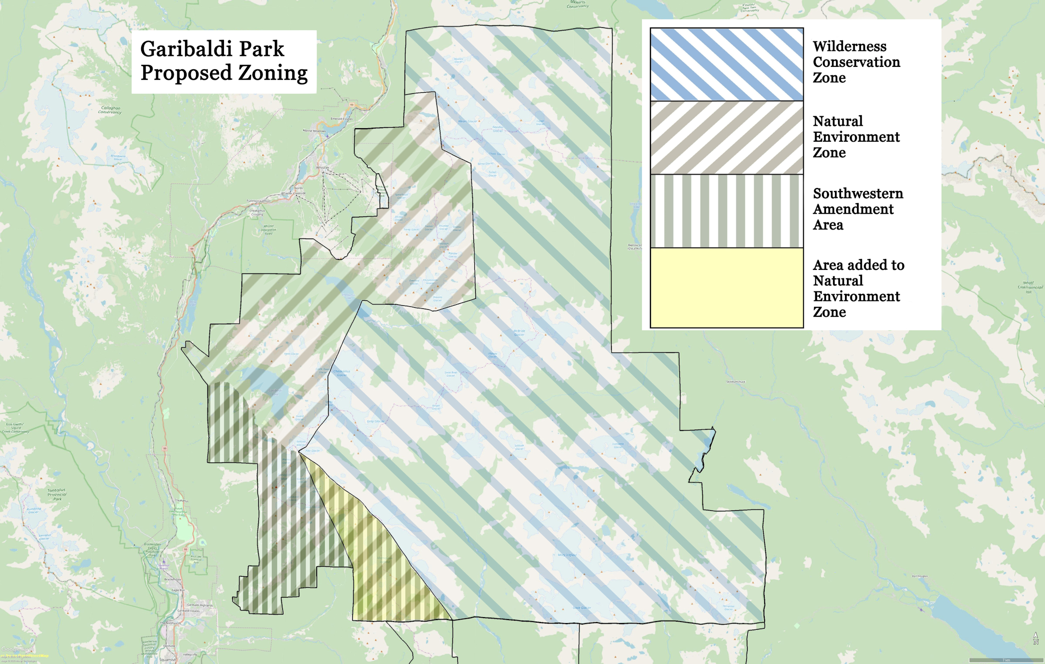
A letter campaign initiated by the British Columbia Mountaineering Club in 1915 followed by a second campaign in 1917 supported by the Alpine Club of Canada (among others) led to the Garibaldi Park Reserve being established April 28, 1920 by Order in Council of the provincial government. One hundred years later, the B.C. Mountaineering Club now proposes the Garibaldi Provincial Park southwestern amendment. The southwestern amendment proposal is for an expansion of the trail and hut network in the southwestern part of Garibaldi Park. It would see five new trailheads into the park established at Alice Lake, Brohm Ridge and Skookum, Swift and Conroy creeks. A zoning change would incorporate Mamquam Lake, Mamquam Icefield, Darling Lake and Crawford Peak areas into the Natural Environment Zone by removing those areas from the Wilderness Conservation Zone. The zoning would permit trail development to Opal Cone and Darling Lake from Skookum Creek. It would emphasize the core recreation values of the park and influence the planning at the adjacent Pinecone Burke Provincial Park and proposed Watersprite Lake Recreation Area.
Recreation Values Historically
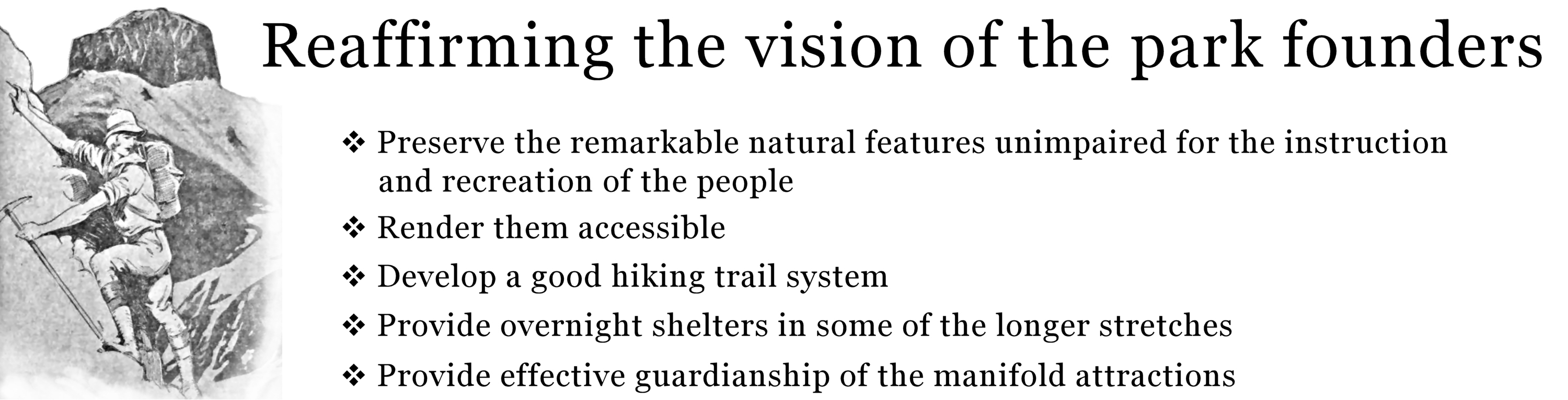
In the 1915 petition, the mountaineering club asked that the park reserve and its "remarkable assemblage of glacial, volcanic and other natural features [be] preserved unimpaired for the instruction and recreation of the people of Western Canada." The Alpine Club in its 1917 letter of support said the alpine tract "is one of great natural beauty and many scenic attractions, and will furnish an easily accessible recreation ground, for the growing population of Vancouver and Victoria." Such reserves it continued provide "an opportunity to visit and enjoy these scenic parks; also, with that object in view, to render them accessible and to provide an effective guardianship of the manifold attractions they possess for Nature-lovers, scientists, artists, mountain-climbers, sight-seers and those in search of renewed vitality."
In 1955, the province convened a royal commission on forestry. At the time, parks were administered under the Forest Act. It was in 1957 that the Department of Recreation and Conservation Act was passed and park administration was transferred from Forests to the new department, the precursor to BC Parks today. A B.C. Mountaineering Club brief to the royal commission cited the general failure of park administration "to give enough attention to the development of a good hiking trail system, with the provision of overnight shelters in some of the longer stretches, and to publicize such trails. It is amazing how good trails, well-marked, will encourage people to walk...such a trail system need not just be limited to Parks, it could be well continued in the regular forest areas..."
In 1990, the master plan for Garibaldi Park was approved. It had a five-year term that expired in 1995. It discussed park classification and zoning. It designated 75% of the park as a Wilderness Conservation Zone (does not permit trails), leaving 25% as Natural Environment Zone (permits trails). The ratio reflected the public support for the wilderness role of the park. The southwestern amendment would reduce the area set aside for wilderness by 4%.
The plan also envisaged expansion of backcountry recreation opportunities. It said, "The proposal to have most of the park as a [wilderness conservancy] and the concerns to have the flexibility in the future to add trails are not mutually exclusive. Although the boundaries of a [wilderness conservancy] are intended to be permanent, they could be altered in the future to accommodate trails, for example, if it is determined that this would best meet the needs of British Columbians."
In 1991, BC Parks released its policy paper, Striking the Balance—an action plan which is fully integrated with the provincial land use strategy. It says "our parks must balance conservation and recreation...We manage parks to provide outstanding recreation without diminishing the value of the natural resources: use without misuse or overuse."
Today, provincial trail strategy emphasizes the “partnership spirit”. The vision of the Trails Strategy for British Columbia is, a world-renowned, sustainable network of trails, with opportunities for all, which provides benefits for trails users, communities and the province.
Highlights of the Southwestern Amendment
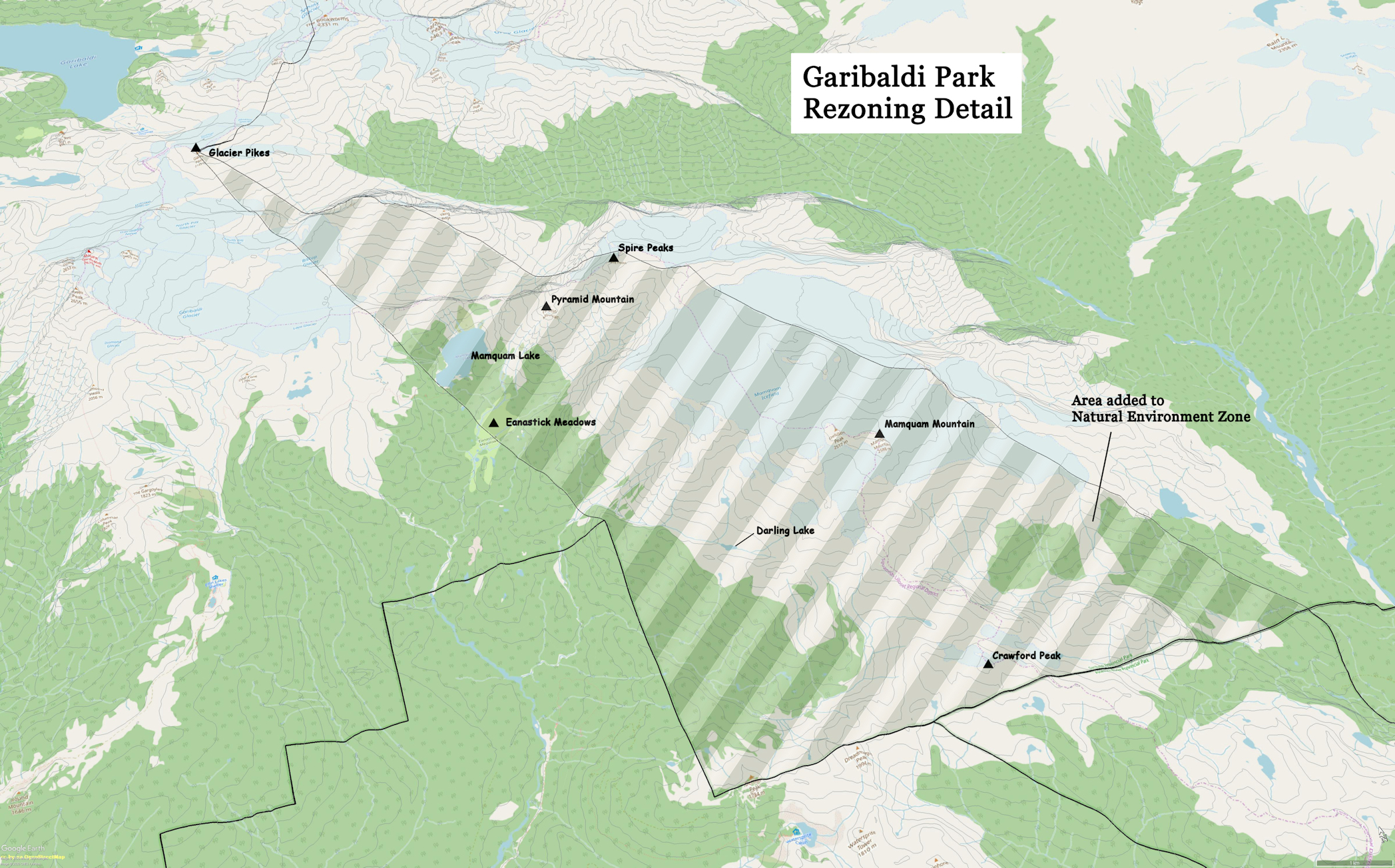
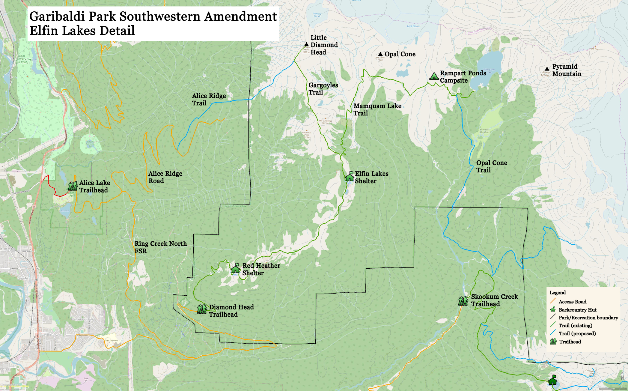
- Rezoning, affecting 4% of the park area, from wilderness conservancy to natural environment. The area includes Mamquam Lake, Mamquam Icefield, Darling Lake, Crawford Peak and Eanastick Meadows.
- Use existing trail heads at Diamond Head (to Elfin Lakes) and Skookum Creek (to Darling Lake). Establish new trail heads at Alice Lake, Brohm Ridge, Swift Creek and Conroy Creek (Chek Canyon recreation site).
- Establish a trail network between Brohm Ridge and Garibaldi Lake to permit long traverses and loops.
- Re-establish the Alice Ridge trail. It would provide connectivity to Elfin Lakes over the Gargoyles and an opportunity for a loop.
- Improve Darling Lake trail from Skookum Creek to provide access to Mamquam Icefield and Mamquam Mountain. It would include an all-season crossing of the east fork of Skookum Creek.
- Establish a new trail between Skookum Creek and Opal Cone via Eanastick Meadows using the established trail head at Skookum Creek. Bridges should be engineered for year-round use.
- Extend the existing trail along Demon Ridge to Dreadnought Peak and provide a connecting route to Watersprite Lake south of the park boundary.
- In the likelihood that the Brohm Ridge resort development proceeds, build an easy to moderately strenuous trail to the Warren Glacier outwash plain from a new park trail head at Swift Creek. Bridges should be engineered for year-round use. Establish free, year-round public access as a condition of the resort’s master development agreement with the province. Implement cost-sharing with the resort on the infrastructure that is of mutual benefit with the province.
- Examine the feasibility, scale and impacts of a backcountry hut on the outwash plain of Warren Glacier. Build, if feasible.
- Examine the need to give protected status to the Ungulate Winter Range designated as MQ-1, an important mountain goat winter range on the west side of Mount Garibaldi in the Cheekye River drainage and bounded on the north by Brohm Ridge.
Trail Design Guidelines
We reference the trail design guidelines published by BC Parks. Trail difficulty combines a difficulty rating and a trail type, e.g. Easy, Type I.
|
Difficulty code |
Difficulty description |
Trail type code |
Trail type description |
|
E |
Easy |
Type I |
1.5 to 2.5 m wide, paved, gravel or board walk, less than 10% grade. |
|
M |
Moderate |
Type II |
1.5 m wide, gravel surfacing in wet areas, up to 15% grade. |
|
S |
Strenuous |
Type III |
0.5 m wide, grade greater than 15% |
|
D |
Difficult |
Type IV |
0.3 m wide, lightly used wilderness trail, infrequent maintenance. |
Example ratings from the Garibaldi Park web site
- Parking lot to Red Heather Meadows: Strenuous, Type II
- Red Heather Meadows to Elfin Lakes: Moderate, Type II
- Black Tusk Junction to Black Tusk Viewpoint: Difficult, Type III
- Elfin Lakes to Opal Cone: Strenuous, Type IV
- Elfin Lake to Gargoyles: Difficult, Type IV
Trail sections outside Garibaldi Park primarily follow forestry roads. Trail work would consist of brushing out the roads, restoration of drainage and construction of footbridges over creek crossings, as required.
Phased Implementation
Timelines are given from the date the master plan amendment is approved.
|
Timeline |
Project |
|---|---|
|
1 to 2 years |
Upgrade Darling Lake trail to type III (Skookum Creek to Darling Lake) Establish the Demon Ridge trail as a type IV trail Engineering studies for Skookum Creek footbridges (three proposed) Engineering studies for Culliton Creek footbridges below Warren Glacier (probably two required) |
|
3 to 5 years |
Upgrade Brohm Ridge trail to type II New footbridge over the east fork of Skookum Creek (Darling Lake trail) New bridge over the east fork of Skookum Creek (Eanastick Meadows access) Build a trail from Skookum Creek to Eanastick Meadows to type III Build the Warren Glacier trail from Swift Creek trailhead to type II Upgrade Alice Ridge trail to type III (from FSR to Little Diamond Head) Study the feasibility of a Warren Glacier hut |
|
6 to 15 years |
Continue trail from Eanastick Meadows to Opal Cone as type III (requires footbridge over Skookum Creek at Eanastick Meadows) Build a trail from Brohm Ridge to Mount Price to type III except type IV between Clinker Peak and Mount Price Build the Clinker Ridge trail from Conroy Creek FSR to Clinker Peak as type III or IV Build Warren Glacier hut, as approved |
Potential Funding Sources
- BC Parks Enhancement Fund.
- Establish partnership agreements with outdoor clubs under the BC Parks Volunteers program for provision of labour, expertise and access to park enhancement funding.
- BC Rural Dividend Program for access road improvement, trails and sanitary facilities.
- Recreation Sites and Trails BC for infrastructure funding along approach corridors outside the park.
- Establish partnership agreements with outdoor clubs through Recreation Sites and Trails BC for provision of labour, expertise and access to provincial funding for projects.
- Solicit donations for infrastructure through charitable organizations such as the British Columbia Mountain Foundation.
- Solicit corporate donations.
- Increased park ranger presence funded by provincial government in recognition of the role the park plays in the provincial economy and the health and well-being of its citizens.
- Revenue arising from the projected increase in backcountry camping permits.
- Negotiate with Garibaldi at Squamish resort to fund infrastructure, parking and sanitary facilities of mutual benefit to BC Parks. E.g. Brohm Ridge trail and trail head. Swift Creek access road and trail head. Trail to Warren Glacier.
- Negotiate with Squamish municipality to provide access road improvements, transit service to trail heads on municipal land, where possible.
- The anticipated increase in park use permit fees attributable to the expansion of recreation opportunities in the park.
Trail Projects
Alice Ridge Trail
The trail along Alice Ridge dates back to at least the 1970s when road access up Alice Ridge was permitted and feasible to private vehicles. At present, roads are gated at Mashiter Creek on Ring Creek North FSR and at Alice Lake on the Alice Ridge road. The trail can be picked up in the old growth forest near the park boundary but is poorly defined although a few trail markers can still be found in places.
The road has seen some recent logging in the lower reaches of the ridge and can be easily driven. The upper part of the road to 1300 meters elevation is very rugged and requires high clearance 4WD. It has not seen recent maintenance. At the top, a side road branches off to an aluminum cache on poles. The cache can sometimes be seen from Highway 99 south of Squamish when the sun reflects off its shiny exterior. The ridge flattens out here and vehicle access ends. About 1 ½ kilometers of second growth forest stands between the road end and the old growth forest. The trail is non-existent in the logged area. One trail option is to follow the ridge crest more or less level but higher than a parallel logging road to the south. The lower road is badly overgrown and the road prism has had the side cast pulled back to recontour the road bed. There is little advantage in using it as a backcountry trail. About halfway from the cache to the park boundary, or approximately 1.3 kilometers, a series of tension cracks cross the ridge and create a landslide hazard. The tension cracks have been studied quite extensively and have been judged by recent studies to have a low probability of catastrophic failure. If a tension crack failed, it would have the potential to form a massive debris flow that could wipe out Highway 99 at Cheekye River and destroy part of Brackendale and the airport. A developer is planning a $45 million debris barrier for Cheekye River that would be paid for by 600 homeowners at a planned development in the debris path.
The tension cracks form abrupt troughs and ridges that the old trail works its way through. Past the cracks, about a half dozen in number, the tree canopy opens up and gives way to open expanses and moderately strenuous hiking over fine volcanic rubble to Little Diamond Head summit.
We would establish Alice Ridge trail as a Type III trail in the 3 to 5-year time frame. The main trail building effort needed is to establish a route through the second growth. Next would be to improve the travel through the area of the tension cracks. Above the cracks and as the tree cover subsides, the natural route is to follow the well-defined ridge crest. An abrupt drop off all along the ridge into Cheekye River accentuates the ridge line and provides spectacular viewing opportunities of Mount Garibaldi. Simple trail cairns would suffice to define the route. Near the summit of Little Diamond Head, a beaten path gains the ridge from the Gargoyles. It raises the possibility of entering or exiting from the Diamond Head parking lot to create a long, one day traverse route between Alice and Paul ridges. Mountaineering parties can continue across the Diamond and upper Garibaldi glaciers to ascend Mount Garibaldi, Dalton Dome and Atwell Peak.
We would not encourage private vehicle access to Alice Ridge road except as may be required for trail work parties. Public hiking access would be from Alice Lake where there is a paved road and parking facilities.
Trail to Opal Cone from Skookum Creek
This proposed trail is an ambitious undertaking that would likely take 5 to 10 years to come to fruition. It would link the Skookum Creek area with Elfin Lake trail that originates at the Diamond Head parking lot. As it is suggested in this proposal, it requires two year-round crossings of Skookum Creek. The creek is fish-bearing and has a high flow supporting a run-of-river facility. Crossing spans in the lower reaches are probably too wide for a log stringer footbridge. A crossing probably requires an engineered structure possibly costing in the $50,000 to $100,000 range based on a recent engineering study for a footbridge across Fitzsimmons Creek in the Whistler area with somewhat similar riverine and span characteristics.
Its primary benefits are to provide a long-distance hiking option to Elfin Lakes and to provide mountaineering and backcountry skiing options to Pyramid Mountain, Spire Peaks and skiing descents off Mamquam Icefield. The midpoint approximately of the trail is Eanastick Meadows. The “meadows” are in actuality a willow swamp and would not be an attractive destination unto itself. The area nearby does have a couple of extinct cinder cones that may provide some interest to visitors. It is envisaged that mountaineers would eventually beat a rough path towards Pyramid Mountain and Spire Peaks by crossing the meadows to the drainage eastwards. There is camping available at Rampart Ponds. It is likely that backcountry bivouac sites might be established near Eanastick Meadows.
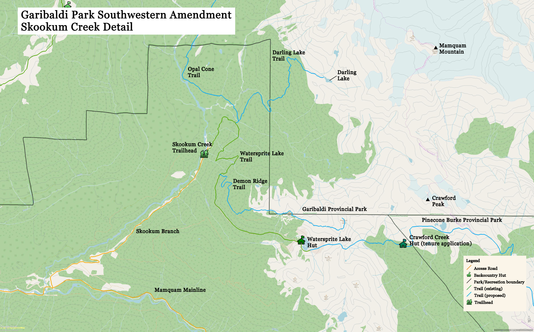
Darling Lake Trail
Darling Lake trail is along a recognized important backcountry access corridor in the Sea to Sky Land and Resource Management Plan. There is a beaten path following a route that has been in place since at least 1977, as recorded in a Varsity Outdoor Club publication.
Within a timeline of 2 years it is possible to upgrade the Darling Lake trail from its current state as a beaten path to a Type III trail. The trail branches off Watersprite Lake trail following a decommissioned logging road (Skookum S2 road) to the old growth forest edge along the east fork of Skookum Creek. An existing, natural log footbridge crosses the creek. The creek itself is a Class C stream—no fish present, steep gradient, log jams and waterfalls present. It is dangerous to ford due to deep, fast water and boulders. The log footbridge can be readily supplied with a taut hand line strung between trees on opposing sides.
Ultimately, a new all-season footbridge should be built 100 meters higher where the creek drains out of a large swamp. This is proposed in the 3 to 5-year time frame. There is an easy crossing point where the stream bed is confined in a narrow channel with grassy banks and a sand and pebble gravel bottom. Several large trees have blown down nearby and could be fashioned into an all-season footbridge. It would require some re-routing of the existing trail. One option is to build a new trail from higher up off the Watersprite Lake trail at the so-called Skullhead #2 footbridge, in reference to the unofficially named Skullhead Creek. The trail, if re-routed, would follow easy to moderately steep terrain from Skullhead Creek through old growth forest to reach the swamp outlet. The second option would be to follow Skookum Creek from the existing crossing to the swamp outlet above. Once established, the first option would likely entail less maintenance effort as it would avoid the necessity of annually clearing brush from one additional kilometer of the decommissioned S2 logging road.
Across the creek, the trail enters Garibaldi Provincial Park about 400 meters beyond the creek. Some trail optimization is possible to reduce the steepness of some grades by building switchbacks or trail re-routing. Reflective markers should be nailed to trees to aid navigation. Near the ridge separating the creek from Darling Lake, the tree cover subsides and becomes non-existent at the lake. Cairns would suffice to delineate the route. There is some limited ground at the lake suitable for tenting. Beyond the lake, difficult rock slides must be crossed to reach glacial ice. There are mountaineering objectives around Mamquam Icefield, such as Mamquam Mountain, Delusion Peak and Darling Peak. Darling Lake is an azure blue and very scenic. There are scrambling opportunities on the ridge to the south of the lake.
Demon Ridge Trail
The so-called Demon Ridge divides Watersprite Creek from the east fork of Skookum Creek. Logging roads go high on the ridge. Currently, a short, cleared path leads partway to the ridge crest. The ridge can be followed to a 1784-meter summit just inside Garibaldi Park or two kilometers further to an 1994-meter summit known unofficially as Dreadnought Peak.
The trail is anticipated to be primarily a scenic ridge walk with the option of scrambling or easy mountaineering to Dreadnought Peak. A descent to Watersprite Lake can be made by a rough route to make a loop trip. Not much work is required to upgrade the route to a Type IV trail. It could be accomplished in the 1 to 2-year timeframe as the B.C. Mountaineering Club has a hut at Watersprite Lake and conducts annual trail maintenance work on Watersprite Lake trail.
Brohm Ridge, Swift Creek, Conroy Creek trails
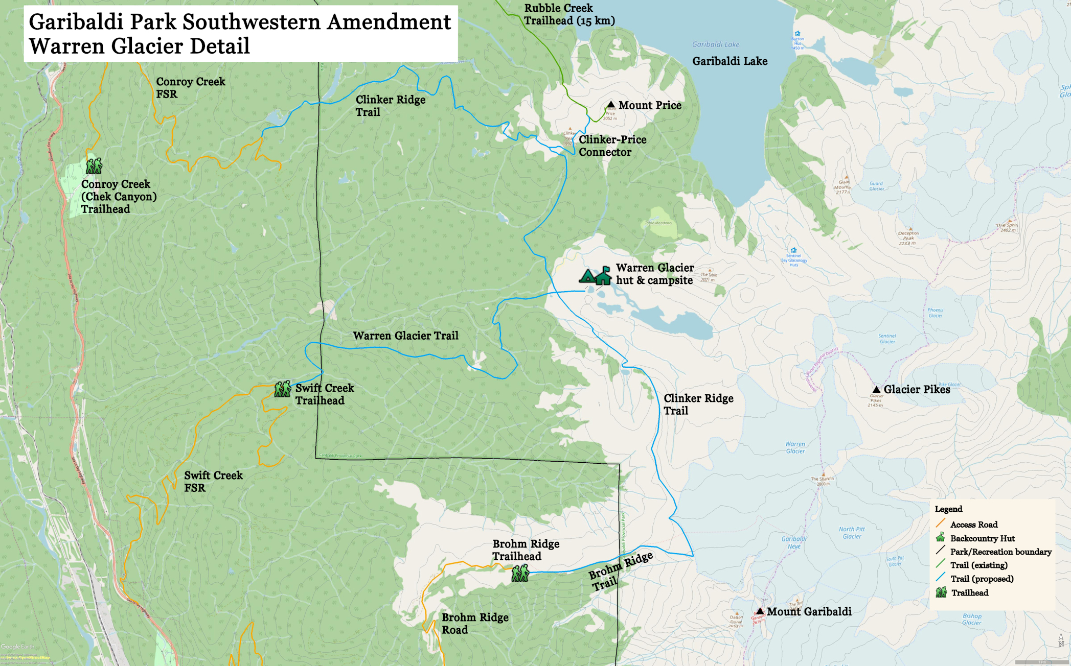
The park area between Brohm Ridge and Garibaldi Lake is currently ill-served by trail access. Brohm Ridge is a major access route for mountaineering and backcountry skiing parties attempting Mount Garibaldi. Mount Price is reached from Battleship Islands on Garibaldi Lake by a very rough route. BC Parks does not list either route on its trail conditions report. There are no other defined routes or trails in the area.
It is somewhat likely that the Brohm Ridge resort development proposed by the Aquilini Group will proceed in the next five years. If approved, it will likely operate under the provincial All Seasons Resort Policy. There must be provisions for public access through the resort to the park lands beyond or else some reasonable alternative must be provided. The resort developer has committed $75,000 to help BC Parks fund a master plan amendment to accommodate its aspirations. The amendment proposed by the resort should be rolled in together with this southwestern amendment and dealt with at the same time.
What we are proposing is that the resort accommodate and financially support trails and trail head infrastructure that will benefit its guests and by the same token, the general public. That is why we are presenting an ambitious plan with a 3 to 15-year time horizon for trail heads at Brohm Ridge (inside the controlled recreation area, TBD) and one at Swift Creek on an existing logging road north of Brohm Ridge. The Brohm Ridge trail to some extent already exists as there is a road up Cheekye River FSR that extends along the ridge with a path at the end leading into the park. In winter, access would be restricted due to downhill skiing operations if the resort proposal succeeds. An alternate public route into the park must be established. We are suggesting that a new park trail head be established off Swift Creek FSR and a new trail to Warren Glacier is the best candidate to provide year-round access to the park.
We are proposing to link the Garibaldi Lake area to Brohm Ridge by constructing a trail between Brohm Ridge and Clinker Ridge and to Mount Price. The trail from Swift Creek would intersect the Brohm-Clinker trail on the outwash plain of Warren Glacier. The trail interconnections would permit loops and traverses between trail heads at Rubble Creek, Swift Creek and Brohm Ridge. If the Clinker Ridge trail were to proceed, it would add the proposed trail at Conroy Creek (Chek Canyon) as another point of access.
The Warren Glacier trail is proposed as an all-season, year-round trail. In summer, there would be hiking opportunities to Brohm Ridge and Clinker Ridge. In winter, the trail would provide access to a ski route up Warren Glacier to Mount Garibaldi with a phenomenal 1200-meter descent. It is proposed to study the feasibility of a hut on the outwash plain of Warren Glacier. The hut would be open year-round and act as a destination to reduce or localize environmental impact, an overnight stopover for long distance hikes and a ski base in winter.