![]()

Park Boundaries
- Written by: Chris Ludwig
- Hits: 2690
Whistler-Blackcomb Park Deletions in context:
- Min Elevation
- 0 m
- Total Distance
- 289.03 km
- Max Elevation
- 0 m
- Total Time
- 0h 00m 00s
- Total Elevation Gain
- 0 m
- Way Points
- 0
- Total Elevation Loss
- 0 m
- Track Points
- 3667
- Max Speed
- 0 m/s
- Route Points
- 0
- Average Speed
- 0 m/s
|
This track was downloaded 1 time(s). Please register/login to download this track. |
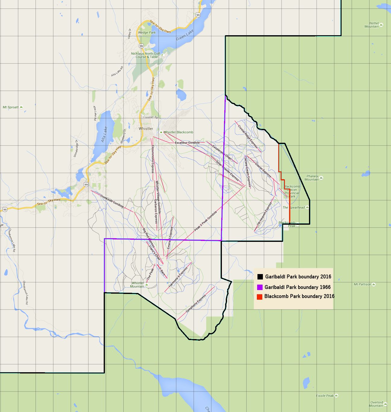
The map outline shows the 2016 Garibaldi Provincial Park boundary, Blackcomb Glacier Provicial Park boundary and the 1966 Garibaldi Provincial Park boundary.
Alternative Map/Presentation:
- Written by: Paul Kubik
- Hits: 3256
Garibaldi Park 2020 proposes two additions to be made to Garibaldi Park at the time of the new master plan. These additions will serve to protect important Mountain Goat habitat. Furthermore, being that at least six Boundary Adjustments have deleted large amounts of land from Garibaldi Park, it is long overdue to begin replacing what has been lost/taken away.
Our proposed additions are as follows (internal links):
Brohm Ridge Addition:
Clinker Ridge Addition:
- Written by: Paul Kubik
- Hits: 4224
This addition to Garibaldi Park protects threatened mountain goat winter range and migration corridor on Clinker Ridge. The winter range is designated WR-2 and WR-3 and includes all the area that is not already in the park.
Click Here for Gmap Rendering
- Min Elevation
- 0 m
- Total Distance
- 17.51 km
- Max Elevation
- 0 m
- Total Time
- 0h 00m 00s
- Total Elevation Gain
- 0 m
- Way Points
- 0
- Total Elevation Loss
- 0 m
- Track Points
- 0
- Max Speed
- 0 m/s
- Route Points
- 408
- Average Speed
- 0 m/s
|
This track was downloaded 0 time(s). Please register/login to download this track. |
- Written by: Paul Kubik
- Hits: 4341
This addition to Garibaldi Park protects threatened mountain goat winter range and migration corridor on Brohm Ridge. The winter range is designated MQ-1 and includes all of MQ-1 that is not already in the park.
Click Here for Gmap Rendering
- Min Elevation
- 0 m
- Total Distance
- 15.43 km
- Max Elevation
- 0 m
- Total Time
- 0h 00m 00s
- Total Elevation Gain
- 0 m
- Way Points
- 0
- Total Elevation Loss
- 0 m
- Track Points
- 0
- Max Speed
- 0 m/s
- Route Points
- 394
- Average Speed
- 0 m/s
|
This track was downloaded 0 time(s). Please register/login to download this track. |
- Written by: Chris Ludwig
- Hits: 4031
This is the Blackcomb Glacier Provincial Park boundary from Open Street Map. The waypoint density is thickened to 100 meters.
Blackcomb Glacier Provincial Park was created from lands that were deleted from Garibaldi Provincial Park. The idea was to make it easier to give away Blackcomb Glacier park lands to Whistler-Blackcomb since it could not be viewed as a deletion from Garibaldi Park.
Click Here for Gmap Rendering
- Min Elevation
- 0 m
- Total Distance
- 8.26 km
- Max Elevation
- 0 m
- Total Time
- 0h 00m 00s
- Total Elevation Gain
- 0 m
- Way Points
- 0
- Total Elevation Loss
- 0 m
- Track Points
- 0
- Max Speed
- 0 m/s
- Route Points
- 94
- Average Speed
- 0 m/s
|
This track was downloaded 0 time(s). Please register/login to download this track. |
More Articles …
Page 1 of 2