Backcountry BC
Backcountry BC
  • Home
    • About
    • Recent Articles
    • Recent Documents
    • Latest Tracks/Trips
  • Issues
    • Active Campaigns
    • Mainland / Southwest
    • Vancouver Island/Coast/Gulf Islands
    • Thompson - Okanagon
    • Kootenay
    • Cariboo
    • North Coast / Nechako
    • Northeast
    • Province Wide
    • BC Region Boundaries
  • Documents
    • Document and File Repository
    • Advanced Site Search
    • About the Document and File Repository
  • Proposals
    • Garibaldi Southwest Amendment
    • Coquitlam to Squamish Trail
  • Maps and Media
    • Custom Maps
      • Mamquam Custom Map
      • Brohm Ridge Custom Map
      • Singing Pass Custom Map
      • Spearhead Heli-skiing Custom Map
      • Garibaldi Park Wilderness Conservation Zone
      • Garibaldi Park Whistler-Blackcomb Deletions
      • Pinecone Burke Proposed Trails
      • Watersprite Custom Map
    • Mapping Data Repository
    • Resource/Trip Planning Maps
      • BC Mountain Specific Weather
      • BC Dynamic Weather Map
      • BC Avalanche Forecast
      • Backroadstatus Dynamic Map
      • BC Strava Heat Map
      • Crown Land Use Application Dynamic Map
      • BC Environmental Assessment Dynamic Map
      • High Elevation Weather Station Dynamic Map/Webcams
      • BC Parks Dynamic Map
      • Forest Service Road Dynamic Map (not maintainted)
    • GPS and Mapping Tools
      • WTracks GPX Editor
      • CalTopo GPX Edit and Render Tool
      • Additional GPX/KML Tools
      • Render GPX File in Open Topo Map
    • Photo Galleries
    • Videos Galleries
  • Resources
    • Trails Database
    • Trails Database Overview Map
    • Reference Articles
    • FAQ
    • Privacy Policy
    • Terms of Use
  • Contact

ORC Trail / Wilderness Review

  1. You are here:  
  2. Home
  3. Issues
  4. Province Wide
  5. People and Facilities
  6. ORC Trail / Wilderness Review

ORC Trail / Wilderness Review

ORC Trail / Wilderness Review

Written by: Paul Kubik
Created: 20 June 2020
Hits: 3742
Outdoor Recreation Council of BC position: No new hiking trails within 160 km (average) of Vancouver "until a wilderness survey is complete."
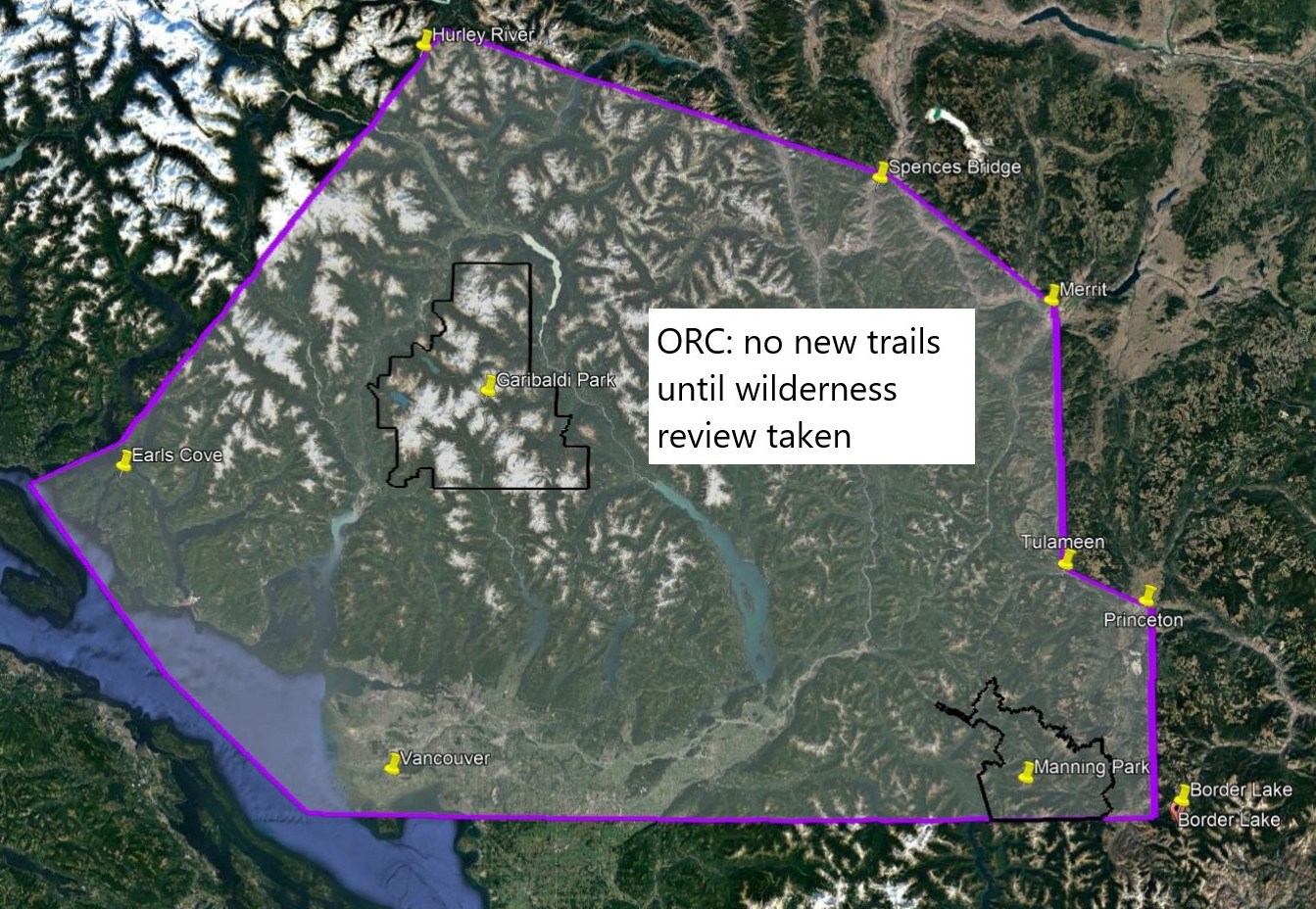
In a sweeping arc from Border Lake in the upper Pasayten River to Princeton, Tulameen, Merritt, Spences Bridge, Hurley River, Earls Cove down to Vancouver the Outdoor Recreation Council of BC has called for no new hiking trails to be developed "until a wilderness area survey is complete." The area encompasses approximately 40,000 square kilometers. For comparison, Garibaldi Provincial Park encompasses about 2,000 square kilometers. ORC exempts from its review any already approved trails or those for Pinecone Burke and Mount Seymour provincial parks. Those two parks have planning processes underway.
The 160 km (average distance) is "limited to the Lower Mainland - within a 3 hour travel time [from Vancouver] so Sunshine Coast/Lillooet/Boston Bar/Manning- as that is where wilderness is under most threat" according to ORC.
ORC did not specify what the parameters of the review are, its definition of wilderness, nor the time frame in which it would complete.
In 1980, an inventory of wilderness areas within 150 km of Vancouver, conducted for the Federation of Mountain Clubs of B.C., identified the northern portion of the [Pinecone Burke] Park as the closest true wilderness area to the Lower Mainland outside parks that were already regulated at that time (Garibaldi, Golden Ears Provincial Parks), and the closest intact wilderness area to Vancouver. — Management Plan, Background Report Draft, for Pinecone Burke Provincial Park, BC Parks (undated)
Around 1985, wilderness management was incorporated into the mandate of Ministry of Forests.
According to the BC Mountaineering Club, a "wilderness review is a needless duplication of matters undertaken by the province."